Balnarring geodata
Balnarring (Victoria) is a section of populated place; located in Australia in Australia/Melbourne (GMT+11) time zone. With population of 2,179 people, there are 2772 cities with bigger population in this country. Compared to other cities in Australia, 95.3% of cities are located further ↑North; 63.7% of cities are located further →East and 53.7% of cities have higher elevation than Balnarring. Note1


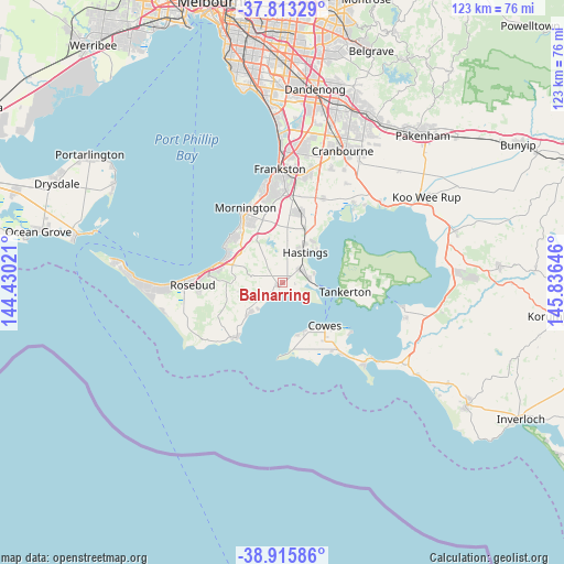
Balnarring GPS coordinates[2]
38° 22' 0.012" South, 145° 7' 59.988" East
| Map corner | latitude | longitude |
|---|---|---|
| Upper-left | -37.81329°, | 144.43021° |
| Center: | -38.36667°, | 145.13333° |
| Lower-right: | -38.91586°, | 145.83646° |
| Map W x H: | 122.6×122.6 km | = 76.2×76.2mi |
| max Lat: | -10.58257° ⇑95.3% North |
| Balnarring: | -38.36667° |
| min Lat: | ⇓4.7% South -43.31423° |
| min Long | Balnarring | max Long |
| 113.53327° | 145.13333° | 153.61246° |
| W 36.3%⇐ | ⇒63.7% E |
Elevation
Elevation of Balnarring is 40 m = 131 ft, and this is 82 m = 269 ft below average elevation for this country.
| Max E: |
1715 m = 5627 ft | 53.7% |
| Avg. | 122 m = 400 ft | |
| Balnarring | 40 m = 131 ft | |
Min E: |
-2 m = -7 ft | 46.3% |
See also: Australia elevation on elevation.city.
Geographical zone
Balnarring is located in South temperate zone (between Tropic of Capricorn and the Antarctic Circle). Distance of this Southern Tropic circle is 1660.1 km =1031.5 mi to North.| Distance of | km | miles | from Balnarring |
|---|---|---|---|
| Equator | 4266 | 2650.8 | to North |
| Tropic Capricorn | 1660.1 | 1031.5 | to North |
| Antarctic Circle | 3135.2 | 1948.1 | to South |
| South Pole | 5741.1 | 3567.4 | to South |


Nearby cities:
15 places around Balnarring: (largest is in red/bold)
• Bittern
4.7 km =2.9 mi,  38°
38°
• Cowes
13.2 km =8.2 mi,  136°
136°
• Crib Point
6.1 km =3.8 mi,  72°
72°
• Dromana
15.2 km =9.4 mi,  283°
283°
• Flinders
15.4 km =9.6 mi,  219°
219°
• Hastings
8.6 km =5.3 mi,  30°
30°
• Hmas Cerberus
5.8 km =3.6 mi,  88°
88°
• Mount Martha
15.1 km =9.4 mi,  317°
317°
• Red Hill
10.3 km =6.4 mi, 280°
• Red Hill South
8.9 km =5.5 mi,  258°
258°
• Safety Beach
12.9 km =8 mi,  296°
296°
• Shoreham
10 km =6.2 mi,  228°
228°
• Somers
2.8 km =1.7 mi,  126°
126°
• Tyabb
13.7 km =8.5 mi,  18°
18°
• Ventnor
12 km =7.5 mi,  153°
153°
Sources, notices
• [Note1] Compared only with cities in Australia existing in our database
• [Src1] Map data: © OpenStreetMap contributors (CC-BY-SA)
• [Src2] Other city data from geonames.org with taken over terms of usage.
• [Src3] Geographical zone / Annual Mean Temperature by Robert A. Rohde @ Wikipedia
