Crib Point geodata
Crib Point (Victoria) is a section of populated place; located in Australia in Australia/Melbourne (GMT+11) time zone. With population of 3,095 people, there are 2190 cities with bigger population in this country. Compared to other cities in Australia, 95.2% of cities are located further ↑North; 62.7% of cities are located further →East and 85% of cities have higher elevation than Crib Point. Note1


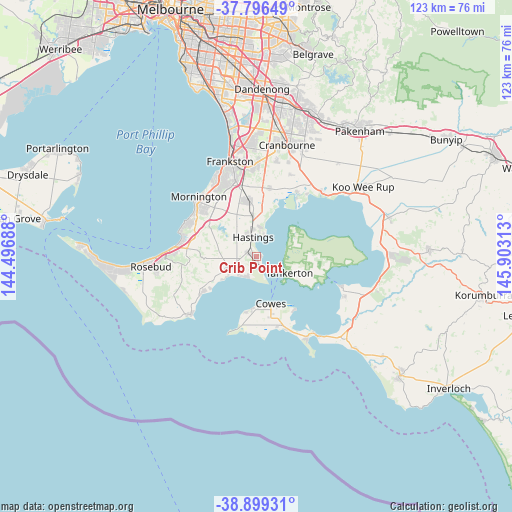
Crib Point GPS coordinates[2]
38° 21' 0" South, 145° 12' 0" East
| Map corner | latitude | longitude |
|---|---|---|
| Upper-left | -37.79649°, | 144.49688° |
| Center: | -38.35°, | 145.2° |
| Lower-right: | -38.89931°, | 145.90313° |
| Map W x H: | 122.6×122.6 km | = 76.2×76.2mi |
| max Lat: | -10.58257° ⇑95.2% North |
| Crib Point: | -38.35° |
| min Lat: | ⇓4.8% South -43.31423° |
| min Long | Crib Point | max Long |
| 113.53327° | 145.2° | 153.61246° |
| W 37.3%⇐ | ⇒62.7% E |
Elevation
Elevation of Crib Point is 12 m = 39 ft, and this is 110 m = 361 ft below average elevation for this country.
| Max E: |
1715 m = 5627 ft | 85% |
| Avg. | 122 m = 400 ft | |
| Crib Point | 12 m = 39 ft | |
Min E: |
-2 m = -7 ft | 15% |
See also: Australia elevation on elevation.city.
Geographical zone
Crib Point is located in South temperate zone (between Tropic of Capricorn and the Antarctic Circle). Distance of this Southern Tropic circle is 1658.2 km =1030.4 mi to North.| Distance of | km | miles | from Crib Point |
|---|---|---|---|
| Equator | 4264.1 | 2649.6 | to North |
| Tropic Capricorn | 1658.2 | 1030.4 | to North |
| Antarctic Circle | 3137.1 | 1949.3 | to South |
| South Pole | 5742.9 | 3568.5 | to South |


Nearby cities:
15 places around Crib Point: (largest is in red/bold)
• Balnarring
6.1 km =3.8 mi,  252°
252°
• Bittern
3.4 km =2.1 mi,  302°
302°
• Cowes
11.9 km =7.4 mi,  163°
163°
• Hastings
5.7 km =3.5 mi,  345°
345°
• Hmas Cerberus
1.7 km =1.1 mi,  178°
178°
• Moorooduc
16.5 km =10.3 mi,  333°
333°
• Phillip Island
15.1 km =9.4 mi,  169°
169°
• Red Hill
16 km =9.9 mi,  270°
270°
• Red Hill South
15 km =9.3 mi,  255°
255°
• Rhyll
15.4 km =9.6 mi,  145°
145°
• Shoreham
15.8 km =9.8 mi,  237°
237°
• Somers
5 km =3.1 mi,  225°
225°
• Somerville
15.1 km =9.4 mi, 348°
• Tyabb
11.2 km =7 mi, 352°
• Ventnor
12.5 km =7.8 mi, 182°
Sources, notices
• [Note1] Compared only with cities in Australia existing in our database
• [Src1] Map data: © OpenStreetMap contributors (CC-BY-SA)
• [Src2] Other city data from geonames.org with taken over terms of usage.
• [Src3] Geographical zone / Annual Mean Temperature by Robert A. Rohde @ Wikipedia
