Somers geodata
Somers (Victoria) is a section of populated place; located in Australia in Australia/Melbourne (GMT+11) time zone. With population of 1,576 people, there are 3213 cities with bigger population in this country. Compared to other cities in Australia, 95.4% of cities are located further ↑North; 63.2% of cities are located further →East and 61.8% of cities have higher elevation than Somers. Note1


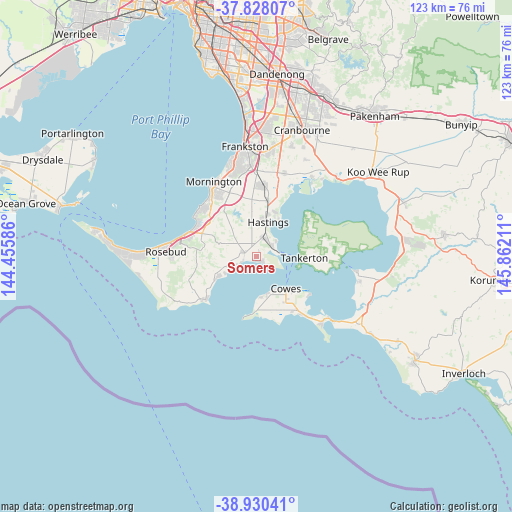
Somers GPS coordinates[2]
38° 22' 52.824" South, 145° 9' 32.328" East
| Map corner | latitude | longitude |
|---|---|---|
| Upper-left | -37.82807°, | 144.45586° |
| Center: | -38.38134°, | 145.15898° |
| Lower-right: | -38.93041°, | 145.86211° |
| Map W x H: | 122.6×122.6 km | = 76.2×76.2mi |
| max Lat: | -10.58257° ⇑95.4% North |
| Somers: | -38.38134° |
| min Lat: | ⇓4.6% South -43.31423° |
| min Long | Somers | max Long |
| 113.53327° | 145.15898° | 153.61246° |
| W 36.8%⇐ | ⇒63.2% E |
Elevation
Elevation of Somers is 30 m = 98 ft, and this is 92 m = 302 ft below average elevation for this country.
| Max E: |
1715 m = 5627 ft | 61.8% |
| Avg. | 122 m = 400 ft | |
| Somers | 30 m = 98 ft | |
Min E: |
-2 m = -7 ft | 38.2% |
See also: Australia elevation on elevation.city.
Geographical zone
Somers is located in South temperate zone (between Tropic of Capricorn and the Antarctic Circle). Distance of this Southern Tropic circle is 1661.7 km =1032.5 mi to North.| Distance of | km | miles | from Somers |
|---|---|---|---|
| Equator | 4267.6 | 2651.8 | to North |
| Tropic Capricorn | 1661.7 | 1032.5 | to North |
| Antarctic Circle | 3133.6 | 1947.1 | to South |
| South Pole | 5739.5 | 3566.4 | to South |


Nearby cities:
15 places around Somers: (largest is in red/bold)
• Balnarring
2.8 km =1.7 mi,  306°
306°
• Bittern
5.4 km =3.4 mi,  7°
7°
• Cowes
10.5 km =6.5 mi,  138°
138°
• Crib Point
5 km =3.1 mi,  45°
45°
• Flinders
15.7 km =9.8 mi,  229°
229°
• Hastings
9.3 km =5.8 mi, 13°
• Hmas Cerberus
4 km =2.5 mi,  63°
63°
• Phillip Island
13 km =8.1 mi,  151°
151°
• Red Hill
12.9 km =8 mi,  285°
285°
• Red Hill South
11 km =6.8 mi,  268°
268°
• Rhyll
15.3 km =9.5 mi,  126°
126°
• Safety Beach
15.7 km =9.8 mi,  297°
297°
• Shoreham
11 km =6.8 mi,  242°
242°
• Tyabb
14.8 km =9.2 mi, 8°
• Ventnor
9.6 km =6 mi,  160°
160°
Sources, notices
• [Note1] Compared only with cities in Australia existing in our database
• [Src1] Map data: © OpenStreetMap contributors (CC-BY-SA)
• [Src2] Other city data from geonames.org with taken over terms of usage.
• [Src3] Geographical zone / Annual Mean Temperature by Robert A. Rohde @ Wikipedia
