Port Campbell geodata
Port Campbell (Victoria) is a populated place; located in Australia in Australia/Melbourne (GMT+11) time zone. With population of 554 people, there are 4693 cities with bigger population in this country. Compared to other cities in Australia, 96.1% of cities are located further ↑North; 74% of cities are located further →East and 79% of cities have higher elevation than Port Campbell. Note1


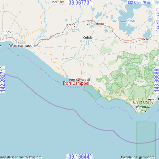
Port Campbell GPS coordinates[2]
38° 37' 9.084" South, 142° 59' 44.988" East
| Map corner | latitude | longitude |
|---|---|---|
| Upper-left | -38.06773°, | 142.29271° |
| Center: | -38.61919°, | 142.99583° |
| Lower-right: | -39.16644°, | 143.69896° |
| Map W x H: | 122.2×122.2 km | = 75.9×75.9mi |
| max Lat: | -10.58257° ⇑96.1% North |
| Port Campbell: | -38.61919° |
| min Lat: | ⇓3.9% South -43.31423° |
| min Long | Port Campbell | max Long |
| 113.53327° | 142.99583° | 153.61246° |
| W 26%⇐ | ⇒74% E |
Elevation
Elevation of Port Campbell is 16 m = 52 ft, and this is 106 m = 348 ft below average elevation for this country.
| Max E: |
1715 m = 5627 ft | 79% |
| Avg. | 122 m = 400 ft | |
| Port Campbell | 16 m = 52 ft | |
Min E: |
-2 m = -7 ft | 21% |
See also: Australia elevation on elevation.city.
Geographical zone
Port Campbell is located in South temperate zone (between Tropic of Capricorn and the Antarctic Circle). Distance of this Southern Tropic circle is 1688.1 km =1048.9 mi to North.| Distance of | km | miles | from Port Campbell |
|---|---|---|---|
| Equator | 4294.1 | 2668.2 | to North |
| Tropic Capricorn | 1688.1 | 1048.9 | to North |
| Antarctic Circle | 3107.1 | 1930.7 | to South |
| South Pole | 5713 | 3549.9 | to South |


Nearby cities:
15 places around Port Campbell: (largest is in red/bold)
• Allansford
43.5 km =27 mi,  306°
306°
• Apollo Bay
60.7 km =37.7 mi,  104°
104°
• Bushfield
52.4 km =32.6 mi, 307°
• Camperdown
44.9 km =27.9 mi,  17°
17°
• Cobden
33 km =20.5 mi,  12°
12°
• Colac
60 km =37.3 mi,  58°
58°
• Dennington
57.1 km =35.5 mi,  300°
300°
• Elliminyt
57.8 km =35.9 mi, 61°
• Koroit
65.7 km =40.8 mi, 303°
• Mortlake
62 km =38.5 mi,  344°
344°
• Port Fairy
71 km =44.1 mi,  291°
291°
• Simpson
25.6 km =15.9 mi, 59°
• Terang
42.6 km =26.5 mi,  351°
351°
• Timboon
15.1 km =9.4 mi, 354°
• Warrnambool
51.5 km =32 mi, 300°
Sources, notices
• [Note1] Compared only with cities in Australia existing in our database
• [Src1] Map data: © OpenStreetMap contributors (CC-BY-SA)
• [Src2] Other city data from geonames.org with taken over terms of usage.
• [Src3] Geographical zone / Annual Mean Temperature by Robert A. Rohde @ Wikipedia
