Allansford geodata
Allansford (Victoria) is a populated place; located in Australia in Australia/Melbourne (GMT+11) time zone. With population of 1,478 people, there are 3296 cities with bigger population in this country. Compared to other cities in Australia, 95.6% of cities are located further ↑North; 74.3% of cities are located further →East and 85% of cities have higher elevation than Allansford. Note1


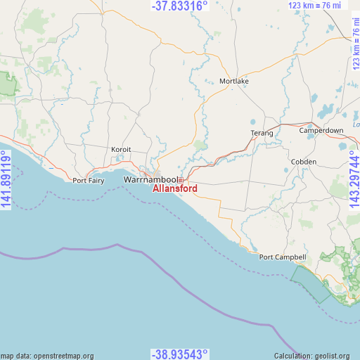
Allansford GPS coordinates[2]
38° 23' 11.004" South, 142° 35' 39.516" East
| Map corner | latitude | longitude |
|---|---|---|
| Upper-left | -37.83316°, | 141.89119° |
| Center: | -38.38639°, | 142.59431° |
| Lower-right: | -38.93543°, | 143.29744° |
| Map W x H: | 122.6×122.6 km | = 76.2×76.2mi |
| max Lat: | -10.58257° ⇑95.6% North |
| Allansford: | -38.38639° |
| min Lat: | ⇓4.4% South -43.31423° |
| min Long | Allansford | max Long |
| 113.53327° | 142.59431° | 153.61246° |
| W 25.7%⇐ | ⇒74.3% E |
Elevation
Elevation of Allansford is 12 m = 39 ft, and this is 110 m = 361 ft below average elevation for this country.
| Max E: |
1715 m = 5627 ft | 85% |
| Avg. | 122 m = 400 ft | |
| Allansford | 12 m = 39 ft | |
Min E: |
-2 m = -7 ft | 15% |
See also: Australia elevation on elevation.city.
Geographical zone
Allansford is located in South temperate zone (between Tropic of Capricorn and the Antarctic Circle). Distance of this Southern Tropic circle is 1662.2 km =1032.8 mi to North.| Distance of | km | miles | from Allansford |
|---|---|---|---|
| Equator | 4268.2 | 2652.1 | to North |
| Tropic Capricorn | 1662.2 | 1032.8 | to North |
| Antarctic Circle | 3133 | 1946.8 | to South |
| South Pole | 5738.9 | 3566 | to South |


Nearby cities:
15 places around Allansford: (largest is in red/bold)
• Bushfield
9 km =5.6 mi,  311°
311°
• Camperdown
51.3 km =31.9 mi,  70°
70°
• Cobden
42.4 km =26.3 mi,  81°
81°
• Dennington
14.4 km =8.9 mi,  283°
283°
• Dunkeld
84.8 km =52.7 mi,  345°
345°
• Koroit
22.4 km =13.9 mi,  297°
297°
• Macarthur
64.9 km =40.3 mi, 307°
• Mortlake
38.8 km =24.1 mi,  28°
28°
• Penshurst
62.7 km =39 mi,  334°
334°
• Port Campbell
43.5 km =27 mi,  126°
126°
• Port Fairy
31.1 km =19.3 mi,  270°
270°
• Simpson
58.5 km =36.4 mi,  102°
102°
• Terang
32.8 km =20.4 mi,  60°
60°
• Timboon
35.3 km =21.9 mi,  107°
107°
• Warrnambool
9.3 km =5.8 mi, 273°
Sources, notices
• [Note1] Compared only with cities in Australia existing in our database
• [Src1] Map data: © OpenStreetMap contributors (CC-BY-SA)
• [Src2] Other city data from geonames.org with taken over terms of usage.
• [Src3] Geographical zone / Annual Mean Temperature by Robert A. Rohde @ Wikipedia
