Mortlake geodata
Mortlake (Victoria) is a populated place; located in Australia in Australia/Melbourne (GMT+11) time zone. With population of 1,334 people, there are 3443 cities with bigger population in this country. Compared to other cities in Australia, 92.5% of cities are located further ↑North; 74.1% of cities are located further →East and 75.7% of cities have lower elevation than Mortlake. Note1


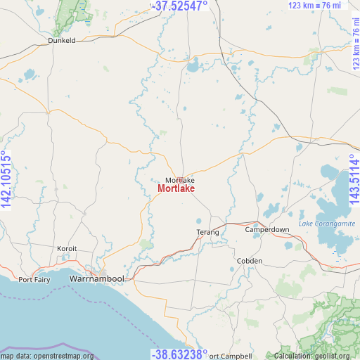
Mortlake GPS coordinates[2]
38° 4' 51.672" South, 142° 48' 29.772" East
| Map corner | latitude | longitude |
|---|---|---|
| Upper-left | -37.52547°, | 142.10515° |
| Center: | -38.08102°, | 142.80827° |
| Lower-right: | -38.63238°, | 143.5114° |
| Map W x H: | 123.1×123.1 km | = 76.5×76.5mi |
| max Lat: | -10.58257° ⇑92.5% North |
| Mortlake: | -38.08102° |
| min Lat: | ⇓7.5% South -43.31423° |
| min Long | Mortlake | max Long |
| 113.53327° | 142.80827° | 153.61246° |
| W 25.9%⇐ | ⇒74.1% E |
Elevation
Elevation of Mortlake is 137 m = 449 ft, and this is 15 m = 49 ft above average elevation for this country.
| Max E: |
1715 m = 5627 ft | 24.3% |
| Mortlake | 137 m 449 ft | |
| Avg. | 122 m = 400 ft | |
Min E: |
-2 m = -7 ft | 75.7% |
See also: Australia elevation on elevation.city.
Geographical zone
Mortlake is located in South temperate zone (between Tropic of Capricorn and the Antarctic Circle). Distance of this Southern Tropic circle is 1628.3 km =1011.8 mi to North.| Distance of | km | miles | from Mortlake |
|---|---|---|---|
| Equator | 4234.2 | 2631 | to North |
| Tropic Capricorn | 1628.3 | 1011.8 | to North |
| Antarctic Circle | 3167 | 1967.9 | to South |
| South Pole | 5772.8 | 3587.1 | to South |


Nearby cities:
15 places around Mortlake: (largest is in red/bold)
• Allansford
38.8 km =24.1 mi,  208°
208°
• Bushfield
37.9 km =23.5 mi,  222°
222°
• Camperdown
34.4 km =21.4 mi,  119°
119°
• Cobden
36.1 km =22.4 mi,  139°
139°
• Dennington
44.7 km =27.8 mi,  227°
227°
• Dunkeld
62.9 km =39.1 mi,  319°
319°
• Koroit
45.1 km =28 mi,  238°
238°
• Penshurst
50.8 km =31.6 mi,  296°
296°
• Port Campbell
62 km =38.5 mi,  164°
164°
• Port Fairy
60.3 km =37.5 mi, 235°
• Simpson
60.7 km =37.7 mi, 140°
• Terang
20.3 km =12.6 mi,  150°
150°
• Timboon
47.3 km =29.4 mi, 161°
• Warrnambool
43.6 km =27.1 mi, 219°
• Willaura
59.9 km =37.2 mi,  354°
354°
Sources, notices
• [Note1] Compared only with cities in Australia existing in our database
• [Src1] Map data: © OpenStreetMap contributors (CC-BY-SA)
• [Src2] Other city data from geonames.org with taken over terms of usage.
• [Src3] Geographical zone / Annual Mean Temperature by Robert A. Rohde @ Wikipedia
