Koroit geodata
Koroit (Victoria) is a populated place; located in Australia in Australia/Melbourne (GMT+11) time zone. With population of 2,022 people, there are 2891 cities with bigger population in this country. Compared to other cities in Australia, 94.7% of cities are located further ↑North; 74.5% of cities are located further →East and 60.7% of cities have lower elevation than Koroit. Note1


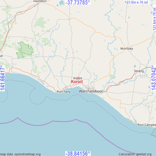
Koroit GPS coordinates[2]
38° 17' 30.48" South, 142° 22' 2.244" East
| Map corner | latitude | longitude |
|---|---|---|
| Upper-left | -37.73785°, | 141.66417° |
| Center: | -38.2918°, | 142.36729° |
| Lower-right: | -38.84156°, | 143.07042° |
| Map W x H: | 122.7×122.7 km | = 76.2×76.2mi |
| max Lat: | -10.58257° ⇑94.7% North |
| Koroit: | -38.2918° |
| min Lat: | ⇓5.3% South -43.31423° |
| min Long | Koroit | max Long |
| 113.53327° | 142.36729° | 153.61246° |
| W 25.5%⇐ | ⇒74.5% E |
Elevation
Elevation of Koroit is 66 m = 217 ft, and this is 56 m = 184 ft below average elevation for this country.
| Max E: |
1715 m = 5627 ft | 39.3% |
| Avg. | 122 m = 400 ft | |
| Koroit | 66 m = 217 ft | |
Min E: |
-2 m = -7 ft | 60.7% |
See also: Australia elevation on elevation.city.
Geographical zone
Koroit is located in South temperate zone (between Tropic of Capricorn and the Antarctic Circle). Distance of this Southern Tropic circle is 1651.7 km =1026.3 mi to North.| Distance of | km | miles | from Koroit |
|---|---|---|---|
| Equator | 4257.6 | 2645.5 | to North |
| Tropic Capricorn | 1651.7 | 1026.3 | to North |
| Antarctic Circle | 3143.5 | 1953.3 | to South |
| South Pole | 5749.4 | 3572.5 | to South |


Nearby cities:
15 places around Koroit: (largest is in red/bold)
• Allansford
22.4 km =13.9 mi,  117°
117°
• Bolwarra
65.5 km =40.7 mi,  270°
270°
• Bushfield
13.8 km =8.6 mi,  109°
109°
• Cobden
61.9 km =38.5 mi,  93°
93°
• Dennington
9.1 km =5.7 mi,  140°
140°
• Heywood
66.8 km =41.5 mi,  285°
285°
• Macarthur
42.9 km =26.7 mi,  311°
311°
• Mortlake
45.1 km =28 mi,  58°
58°
• Penshurst
46.8 km =29.1 mi,  351°
351°
• Port Campbell
65.7 km =40.8 mi, 123°
• Port Fairy
15.4 km =9.6 mi,  227°
227°
• Portland
67 km =41.6 mi,  264°
264°
• Terang
48.7 km =30.3 mi,  83°
83°
• Timboon
57.6 km =35.8 mi, 111°
• Warrnambool
14.5 km =9 mi,  133°
133°
Sources, notices
• [Note1] Compared only with cities in Australia existing in our database
• [Src1] Map data: © OpenStreetMap contributors (CC-BY-SA)
• [Src2] Other city data from geonames.org with taken over terms of usage.
• [Src3] Geographical zone / Annual Mean Temperature by Robert A. Rohde @ Wikipedia
