Bushfield geodata
Bushfield (Victoria) is a populated place; located in Australia in Australia/Melbourne (GMT+11) time zone. With population of 534 people, there are 4768 cities with bigger population in this country. Compared to other cities in Australia, 94.9% of cities are located further ↑North; 74.3% of cities are located further →East and 52% of cities have lower elevation than Bushfield. Note1


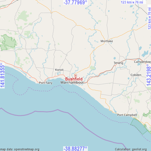
Bushfield GPS coordinates[2]
38° 19' 59.988" South, 142° 31' 0.012" East
| Map corner | latitude | longitude |
|---|---|---|
| Upper-left | -37.77969°, | 141.81355° |
| Center: | -38.33333°, | 142.51667° |
| Lower-right: | -38.88277°, | 143.2198° |
| Map W x H: | 122.7×122.7 km | = 76.2×76.2mi |
| max Lat: | -10.58257° ⇑94.9% North |
| Bushfield: | -38.33333° |
| min Lat: | ⇓5.1% South -43.31423° |
| min Long | Bushfield | max Long |
| 113.53327° | 142.51667° | 153.61246° |
| W 25.7%⇐ | ⇒74.3% E |
Elevation
Elevation of Bushfield is 48 m = 157 ft, and this is 74 m = 243 ft below average elevation for this country.
| Max E: |
1715 m = 5627 ft | 48% |
| Avg. | 122 m = 400 ft | |
| Bushfield | 48 m = 157 ft | |
Min E: |
-2 m = -7 ft | 52% |
See also: Australia elevation on elevation.city.
Geographical zone
Bushfield is located in South temperate zone (between Tropic of Capricorn and the Antarctic Circle). Distance of this Southern Tropic circle is 1656.3 km =1029.2 mi to North.| Distance of | km | miles | from Bushfield |
|---|---|---|---|
| Equator | 4262.3 | 2648.5 | to North |
| Tropic Capricorn | 1656.3 | 1029.2 | to North |
| Antarctic Circle | 3138.9 | 1950.4 | to South |
| South Pole | 5744.8 | 3569.7 | to South |


Nearby cities:
15 places around Bushfield: (largest is in red/bold)
• Allansford
9 km =5.6 mi,  131°
131°
• Camperdown
56.4 km =35 mi,  78°
78°
• Cobden
48.7 km =30.3 mi,  89°
89°
• Dennington
7.6 km =4.7 mi,  251°
251°
• Dunkeld
77.5 km =48.2 mi,  348°
348°
• Koroit
13.8 km =8.6 mi,  289°
289°
• Macarthur
56 km =34.8 mi,  306°
306°
• Mortlake
37.9 km =23.5 mi,  42°
42°
• Penshurst
54.6 km =33.9 mi,  338°
338°
• Port Campbell
52.4 km =32.6 mi, 127°
• Port Fairy
25.1 km =15.6 mi,  256°
256°
• Simpson
66.6 km =41.4 mi,  106°
106°
• Terang
36.8 km =22.9 mi,  73°
73°
• Timboon
43.7 km =27.2 mi, 112°
• Warrnambool
5.9 km =3.7 mi,  204°
204°
Sources, notices
• [Note1] Compared only with cities in Australia existing in our database
• [Src1] Map data: © OpenStreetMap contributors (CC-BY-SA)
• [Src2] Other city data from geonames.org with taken over terms of usage.
• [Src3] Geographical zone / Annual Mean Temperature by Robert A. Rohde @ Wikipedia
