Dennington geodata
Dennington (Victoria) is a populated place; located in Australia in Australia/Melbourne (GMT+11) time zone. With population of 1,842 people, there are 3012 cities with bigger population in this country. Compared to other cities in Australia, 95.2% of cities are located further ↑North; 74.4% of cities are located further →East and 72.3% of cities have higher elevation than Dennington. Note1


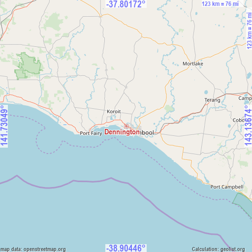
Dennington GPS coordinates[2]
38° 21' 18.684" South, 142° 26' 0.996" East
| Map corner | latitude | longitude |
|---|---|---|
| Upper-left | -37.80172°, | 141.73049° |
| Center: | -38.35519°, | 142.43361° |
| Lower-right: | -38.90446°, | 143.13674° |
| Map W x H: | 122.6×122.6 km | = 76.2×76.2mi |
| max Lat: | -10.58257° ⇑95.2% North |
| Dennington: | -38.35519° |
| min Lat: | ⇓4.8% South -43.31423° |
| min Long | Dennington | max Long |
| 113.53327° | 142.43361° | 153.61246° |
| W 25.6%⇐ | ⇒74.4% E |
Elevation
Elevation of Dennington is 21 m = 69 ft, and this is 101 m = 331 ft below average elevation for this country.
| Max E: |
1715 m = 5627 ft | 72.3% |
| Avg. | 122 m = 400 ft | |
| Dennington | 21 m = 69 ft | |
Min E: |
-2 m = -7 ft | 27.7% |
See also: Australia elevation on elevation.city.
Geographical zone
Dennington is located in South temperate zone (between Tropic of Capricorn and the Antarctic Circle). Distance of this Southern Tropic circle is 1658.8 km =1030.7 mi to North.| Distance of | km | miles | from Dennington |
|---|---|---|---|
| Equator | 4264.7 | 2650 | to North |
| Tropic Capricorn | 1658.8 | 1030.7 | to North |
| Antarctic Circle | 3136.5 | 1948.9 | to South |
| South Pole | 5742.4 | 3568.2 | to South |


Nearby cities:
15 places around Dennington: (largest is in red/bold)
• Allansford
14.4 km =8.9 mi,  103°
103°
• Bolwarra
71.7 km =44.6 mi,  276°
276°
• Bushfield
7.6 km =4.7 mi,  71°
71°
• Camperdown
63.9 km =39.7 mi,  77°
77°
• Cobden
56 km =34.8 mi,  86°
86°
• Koroit
9.1 km =5.7 mi,  320°
320°
• Macarthur
52 km =32.3 mi,  313°
313°
• Mortlake
44.7 km =27.8 mi,  47°
47°
• Penshurst
54.8 km =34.1 mi,  346°
346°
• Port Campbell
57.1 km =35.5 mi,  120°
120°
• Port Fairy
17.5 km =10.9 mi,  258°
258°
• Portland
72.5 km =45 mi,  270°
270°
• Terang
44.4 km =27.6 mi, 73°
• Timboon
49.7 km =30.9 mi,  106°
106°
• Warrnambool
5.6 km =3.5 mi, 121°
Sources, notices
• [Note1] Compared only with cities in Australia existing in our database
• [Src1] Map data: © OpenStreetMap contributors (CC-BY-SA)
• [Src2] Other city data from geonames.org with taken over terms of usage.
• [Src3] Geographical zone / Annual Mean Temperature by Robert A. Rohde @ Wikipedia
