Warrnambool geodata
Warrnambool (Victoria) is a populated place; located in Australia in Australia/Melbourne (GMT+11) time zone. With population of 29,176 people, there are 74 cities with bigger population in this country. Compared to other cities in Australia, 95.5% of cities are located further ↑North; 74.3% of cities are located further →East and 68.6% of cities have higher elevation than Warrnambool. Note1


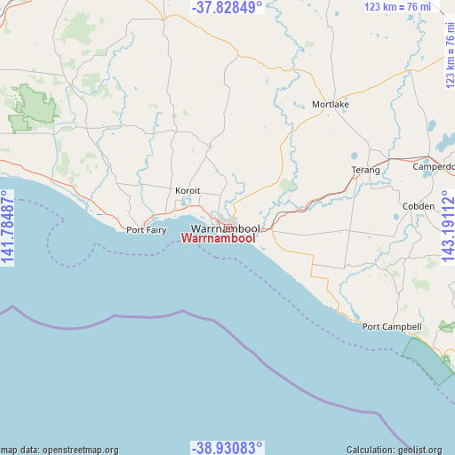
Warrnambool GPS coordinates[2]
38° 22' 54.336" South, 142° 29' 16.764" East
| Map corner | latitude | longitude |
|---|---|---|
| Upper-left | -37.82849°, | 141.78487° |
| Center: | -38.38176°, | 142.48799° |
| Lower-right: | -38.93083°, | 143.19112° |
| Map W x H: | 122.6×122.6 km | = 76.2×76.2mi |
| max Lat: | -10.58257° ⇑95.5% North |
| Warrnambool: | -38.38176° |
| min Lat: | ⇓4.5% South -43.31423° |
| min Long | Warrnambool | max Long |
| 113.53327° | 142.48799° | 153.61246° |
| W 25.7%⇐ | ⇒74.3% E |
Elevation
Elevation of Warrnambool is 24 m = 79 ft, and this is 98 m = 322 ft below average elevation for this country.
| Max E: |
1715 m = 5627 ft | 68.6% |
| Avg. | 122 m = 400 ft | |
| Warrnambool | 24 m = 79 ft | |
Min E: |
-2 m = -7 ft | 31.4% |
See also: Australia elevation on elevation.city.
Geographical zone
Warrnambool is located in South temperate zone (between Tropic of Capricorn and the Antarctic Circle). Distance of this Southern Tropic circle is 1661.7 km =1032.5 mi to North.| Distance of | km | miles | from Warrnambool |
|---|---|---|---|
| Equator | 4267.7 | 2651.8 | to North |
| Tropic Capricorn | 1661.7 | 1032.5 | to North |
| Antarctic Circle | 3133.5 | 1947.1 | to South |
| South Pole | 5739.4 | 3566.3 | to South |


Nearby cities:
15 places around Warrnambool: (largest is in red/bold)
• Allansford
9.3 km =5.8 mi,  93°
93°
• Bolwarra
76.8 km =47.7 mi,  278°
278°
• Bushfield
5.9 km =3.7 mi,  24°
24°
• Camperdown
60 km =37.3 mi,  74°
74°
• Cobden
51.5 km =32 mi,  83°
83°
• Dennington
5.6 km =3.5 mi,  301°
301°
• Koroit
14.5 km =9 mi,  313°
313°
• Macarthur
57.4 km =35.7 mi, 312°
• Mortlake
43.6 km =27.1 mi,  39°
39°
• Penshurst
58.9 km =36.6 mi,  342°
342°
• Port Campbell
51.5 km =32 mi,  120°
120°
• Port Fairy
21.9 km =13.6 mi,  268°
268°
• Simpson
67.7 km =42.1 mi,  101°
101°
• Terang
40.9 km =25.4 mi, 67°
• Timboon
44.4 km =27.6 mi, 104°
Sources, notices
• [Note1] Compared only with cities in Australia existing in our database
• [Src1] Map data: © OpenStreetMap contributors (CC-BY-SA)
• [Src2] Other city data from geonames.org with taken over terms of usage.
• [Src3] Geographical zone / Annual Mean Temperature by Robert A. Rohde @ Wikipedia
