Little River geodata
Little River (Victoria) is a section of populated place; located in Australia in Australia/Melbourne (GMT+11) time zone. With population of 1,283 people, there are 3486 cities with bigger population in this country. Compared to other cities in Australia, 91.5% of cities are located further ↑North; 70.3% of cities are located further →East and 56.9% of cities have higher elevation than Little River. Note1


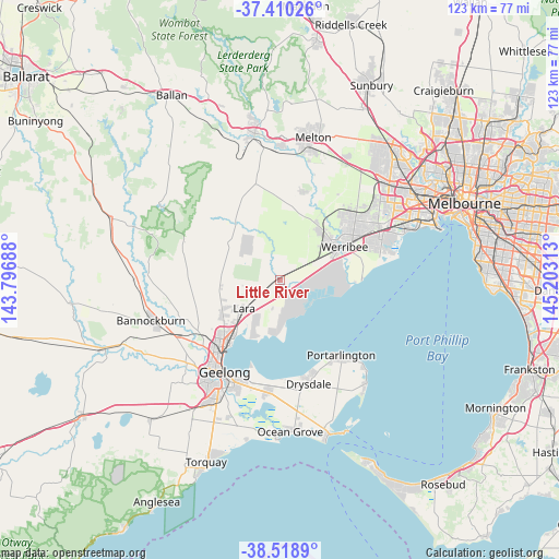
Little River GPS coordinates[2]
37° 58' 0.012" South, 144° 30' 0" East
| Map corner | latitude | longitude |
|---|---|---|
| Upper-left | -37.41026°, | 143.79688° |
| Center: | -37.96667°, | 144.5° |
| Lower-right: | -38.5189°, | 145.20313° |
| Map W x H: | 123.3×123.3 km | = 76.6×76.6mi |
| max Lat: | -10.58257° ⇑91.5% North |
| Little River: | -37.96667° |
| min Lat: | ⇓8.5% South -43.31423° |
| min Long | Little River | max Long |
| 113.53327° | 144.5° | 153.61246° |
| W 29.7%⇐ | ⇒70.3% E |
Elevation
Elevation of Little River is 36 m = 118 ft, and this is 86 m = 282 ft below average elevation for this country.
| Max E: |
1715 m = 5627 ft | 56.9% |
| Avg. | 122 m = 400 ft | |
| Little River | 36 m = 118 ft | |
Min E: |
-2 m = -7 ft | 43.1% |
See also: Australia elevation on elevation.city.
Geographical zone
Little River is located in South temperate zone (between Tropic of Capricorn and the Antarctic Circle). Distance of this Southern Tropic circle is 1615.6 km =1003.9 mi to North.| Distance of | km | miles | from Little River |
|---|---|---|---|
| Equator | 4221.5 | 2623.1 | to North |
| Tropic Capricorn | 1615.6 | 1003.9 | to North |
| Antarctic Circle | 3179.7 | 1975.8 | to South |
| South Pole | 5785.6 | 3595 | to South |


Nearby cities:
15 places around Little River: (largest is in red/bold)
• Bell Park
21.1 km =13.1 mi,  222°
222°
• Bell Post Hill
21.3 km =13.2 mi,  227°
227°
• Corio
16.5 km =10.3 mi, 218°
• Eynesbury
19.6 km =12.2 mi,  19°
19°
• Hoppers Crossing
19.9 km =12.4 mi,  61°
61°
• Lara
10.4 km =6.5 mi, 232°
• Lovely Banks
18.4 km =11.4 mi, 232°
• Mount Cottrell
18.2 km =11.3 mi, 23°
• Norlane
19.7 km =12.2 mi, 220°
• North Geelong
20.5 km =12.7 mi, 219°
• Portarlington
21.4 km =13.3 mi,  140°
140°
• Tarneit
20.1 km =12.5 mi,  44°
44°
• Werribee
16.4 km =10.2 mi, 63°
• Werribee South
19.1 km =11.9 mi,  83°
83°
• Wyndham Vale
13.7 km =8.5 mi,  52°
52°
Sources, notices
• [Note1] Compared only with cities in Australia existing in our database
• [Src1] Map data: © OpenStreetMap contributors (CC-BY-SA)
• [Src2] Other city data from geonames.org with taken over terms of usage.
• [Src3] Geographical zone / Annual Mean Temperature by Robert A. Rohde @ Wikipedia
