Normanton geodata
Normanton (Queensland) is a populated place; located in Australia in Australia/Brisbane (GMT+10) time zone. With population of 1,555 people, there are 3233 cities with bigger population in this country. Compared to other cities in Australia, 96.3% of cities are located further ↓South; 75.4% of cities are located further →East and 85% of cities have higher elevation than Normanton. Note1


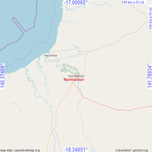
Normanton GPS coordinates[2]
17° 40' 18.588" South, 141° 4' 37.956" East
| Map corner | latitude | longitude |
|---|---|---|
| Upper-left | -17.00065°, | 140.37409° |
| Center: | -17.67183°, | 141.07721° |
| Lower-right: | -18.34051°, | 141.78034° |
| Map W x H: | 149×149 km | = 92.6×92.6mi |
| max Lat: | -10.58257° ⇑3.7% North |
| Normanton: | -17.67183° |
| min Lat: | ⇓96.3% South -43.31423° |
| min Long | Normanton | max Long |
| 113.53327° | 141.07721° | 153.61246° |
| W 24.6%⇐ | ⇒75.4% E |
Elevation
Elevation of Normanton is 12 m = 39 ft, and this is 110 m = 361 ft below average elevation for this country.
| Max E: |
1715 m = 5627 ft | 85% |
| Avg. | 122 m = 400 ft | |
| Normanton | 12 m = 39 ft | |
Min E: |
-2 m = -7 ft | 15% |
See also: Australia elevation on elevation.city.
Geographical zone
Normanton is located in South Torrid zone (between Equator and Tropic of Capricorn). Distance of this Southern Tropic circle is 641 km =398.3 mi to South.| Distance of | km | miles | from Normanton |
|---|---|---|---|
| Equator | 1964.9 | 1220.9 | to North |
| Tropic Capricorn | 641 | 398.3 | to South |
| Antarctic Circle | 5436.3 | 3378 | to South |
| South Pole | 8042.1 | 4997.1 | to South |


Nearby cities:
15 places around Normanton: (largest is in red/bold)
• Cloncurry
342.7 km =212.9 mi,  189°
189°
• Doomadgee
240.1 km =149.2 mi,  262°
262°
• Julia Creek
339 km =210.6 mi,  168°
168°
• Karumba
32.3 km =20.1 mi,  309°
309°
• Kowanyama
254.6 km =158.2 mi,  16°
16°
• Menzies
377.2 km =234.4 mi,  206°
206°
• Mornington
378.8 km =235.4 mi, 205°
• Mount Isa
377.9 km =234.8 mi, 206°
• Pioneer
376.9 km =234.2 mi, 205°
• Pormpuraaw
313.7 km =194.9 mi,  10°
10°
• Soldiers Hill
376.2 km =233.8 mi, 206°
• Sunset
375.9 km =233.6 mi, 205°
• Townview
378.2 km =235 mi, 205°
• Wellesley Islands
212.3 km =131.9 mi,  303°
303°
• Winston
375.6 km =233.4 mi, 206°
Sources, notices
• [Note1] Compared only with cities in Australia existing in our database
• [Src1] Map data: © OpenStreetMap contributors (CC-BY-SA)
• [Src2] Other city data from geonames.org with taken over terms of usage.
• [Src3] Geographical zone / Annual Mean Temperature by Robert A. Rohde @ Wikipedia
