Pyalong geodata
Pyalong (Victoria) is a populated place; located in Australia in Australia/Melbourne (GMT+11) time zone. With population of 643 people, there are 4465 cities with bigger population in this country. Compared to other cities in Australia, 81.9% of cities are located further ↑North; 68.4% of cities are located further →East and 86.8% of cities have lower elevation than Pyalong. Note1


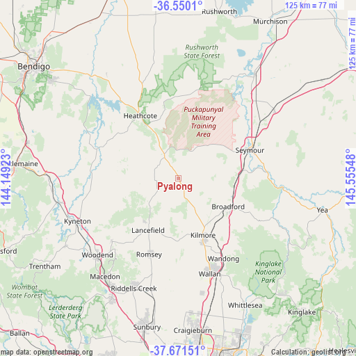
Pyalong GPS coordinates[2]
37° 6' 46.368" South, 144° 51' 8.46" East
| Map corner | latitude | longitude |
|---|---|---|
| Upper-left | -36.5501°, | 144.14923° |
| Center: | -37.11288°, | 144.85235° |
| Lower-right: | -37.67151°, | 145.55548° |
| Map W x H: | 124.7×124.7 km | = 77.5×77.5mi |
| max Lat: | -10.58257° ⇑81.9% North |
| Pyalong: | -37.11288° |
| min Lat: | ⇓18.1% South -43.31423° |
| min Long | Pyalong | max Long |
| 113.53327° | 144.85235° | 153.61246° |
| W 31.6%⇐ | ⇒68.4% E |
Elevation
Elevation of Pyalong is 283 m = 928 ft, and this is 161 m = 528 ft above average elevation for this country.
| Max E: |
1715 m = 5627 ft | 13.2% |
| Pyalong | 283 m 928 ft | |
| Avg. | 122 m = 400 ft | |
Min E: |
-2 m = -7 ft | 86.8% |
See also: Australia elevation on elevation.city.
Geographical zone
Pyalong is located in South temperate zone (between Tropic of Capricorn and the Antarctic Circle). Distance of this Southern Tropic circle is 1520.6 km =944.9 mi to North.| Distance of | km | miles | from Pyalong |
|---|---|---|---|
| Equator | 4126.6 | 2564.1 | to North |
| Tropic Capricorn | 1520.6 | 944.9 | to North |
| Antarctic Circle | 3274.6 | 2034.7 | to South |
| South Pole | 5880.5 | 3654 | to South |


Nearby cities:
15 places around Pyalong: (largest is in red/bold)
• Avenel
41.3 km =25.7 mi,  55°
55°
• Broadford
20 km =12.4 mi,  119°
119°
• Heathcote
24.8 km =15.4 mi,  328°
328°
• Kilmore
22.2 km =13.8 mi,  156°
156°
• Kyneton
38.4 km =23.9 mi,  247°
247°
• Lancefield
21 km =13 mi,  209°
209°
• Malmsbury
42.3 km =26.3 mi,  258°
258°
• Mount Macedon
39.8 km =24.7 mi,  216°
216°
• Puckapunyal
21.2 km =13.2 mi,  51°
51°
• Romsey
28.2 km =17.5 mi,  200°
200°
• Seymour
27.2 km =16.9 mi,  69°
69°
• Tallarook
22.1 km =13.7 mi,  84°
84°
• Wallan
35.5 km =22.1 mi, 161°
• Wandong
32.9 km =20.4 mi,  151°
151°
• Woodend
39.3 km =24.4 mi,  226°
226°
Sources, notices
• [Note1] Compared only with cities in Australia existing in our database
• [Src1] Map data: © OpenStreetMap contributors (CC-BY-SA)
• [Src2] Other city data from geonames.org with taken over terms of usage.
• [Src3] Geographical zone / Annual Mean Temperature by Robert A. Rohde @ Wikipedia
