Puckapunyal geodata
Puckapunyal (Victoria) is a populated place; located in Australia in Australia/Melbourne (GMT+11) time zone. With population of 1,310 people, there are 3462 cities with bigger population in this country. Compared to other cities in Australia, 81.4% of cities are located further ↑North; 65.5% of cities are located further →East and 80.4% of cities have lower elevation than Puckapunyal. Note1


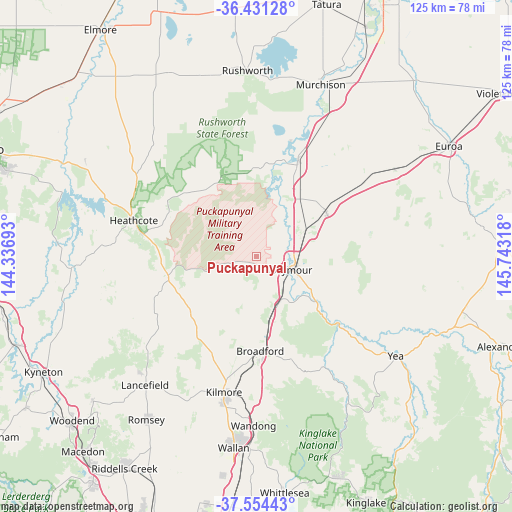
Puckapunyal GPS coordinates[2]
36° 59' 41.748" South, 145° 2' 24.18" East
| Map corner | latitude | longitude |
|---|---|---|
| Upper-left | -36.43128°, | 144.33693° |
| Center: | -36.99493°, | 145.04005° |
| Lower-right: | -37.55443°, | 145.74318° |
| Map W x H: | 124.9×124.9 km | = 77.6×77.6mi |
| max Lat: | -10.58257° ⇑81.4% North |
| Puckapunyal: | -36.99493° |
| min Lat: | ⇓18.6% South -43.31423° |
| min Long | Puckapunyal | max Long |
| 113.53327° | 145.04005° | 153.61246° |
| W 34.5%⇐ | ⇒65.5% E |
Elevation
Elevation of Puckapunyal is 185 m = 607 ft, and this is 63 m = 207 ft above average elevation for this country.
| Max E: |
1715 m = 5627 ft | 19.6% |
| Puckapunyal | 185 m 607 ft | |
| Avg. | 122 m = 400 ft | |
Min E: |
-2 m = -7 ft | 80.4% |
See also: Australia elevation on elevation.city.
Geographical zone
Puckapunyal is located in South temperate zone (between Tropic of Capricorn and the Antarctic Circle). Distance of this Southern Tropic circle is 1507.5 km =936.7 mi to North.| Distance of | km | miles | from Puckapunyal |
|---|---|---|---|
| Equator | 4113.5 | 2556 | to North |
| Tropic Capricorn | 1507.5 | 936.7 | to North |
| Antarctic Circle | 3287.7 | 2042.9 | to South |
| South Pole | 5893.6 | 3662.1 | to South |


Nearby cities:
15 places around Puckapunyal: (largest is in red/bold)
• Avenel
20.1 km =12.5 mi,  58°
58°
• Broadford
23.1 km =14.4 mi,  178°
178°
• Flowerdale
45.7 km =28.4 mi,  145°
145°
• Heathcote
30.6 km =19 mi,  285°
285°
• Kilmore
34.3 km =21.3 mi,  193°
193°
• Lancefield
41.4 km =25.7 mi,  220°
220°
• Murchison
44.7 km =27.8 mi,  20°
20°
• Nagambie
25.4 km =15.8 mi, 23°
• Pyalong
21.2 km =13.2 mi,  231°
231°
• Rushworth
45.4 km =28.2 mi,  357°
357°
• Seymour
9.5 km =5.9 mi,  111°
111°
• Tallarook
12.2 km =7.6 mi, 154°
• Wallan
47.2 km =29.3 mi, 186°
• Wandong
41.9 km =26 mi, 180°
• Yea
41.9 km =26 mi,  124°
124°
Sources, notices
• [Note1] Compared only with cities in Australia existing in our database
• [Src1] Map data: © OpenStreetMap contributors (CC-BY-SA)
• [Src2] Other city data from geonames.org with taken over terms of usage.
• [Src3] Geographical zone / Annual Mean Temperature by Robert A. Rohde @ Wikipedia
