Heathcote geodata
Heathcote (Victoria) is a populated place; located in Australia in Australia/Melbourne (GMT+11) time zone. With population of 2,712 people, there are 2427 cities with bigger population in this country. Compared to other cities in Australia, 81.3% of cities are located further ↑North; 69.6% of cities are located further →East and 84.5% of cities have lower elevation than Heathcote. Note1


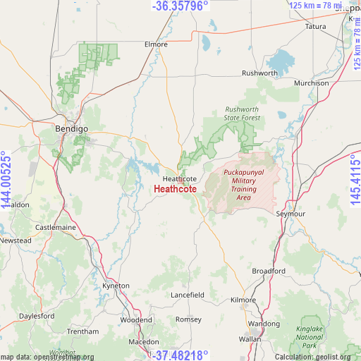
Heathcote GPS coordinates[2]
36° 55' 19.704" South, 144° 42' 30.132" East
| Map corner | latitude | longitude |
|---|---|---|
| Upper-left | -36.35796°, | 144.00525° |
| Center: | -36.92214°, | 144.70837° |
| Lower-right: | -37.48218°, | 145.4115° |
| Map W x H: | 125×125 km | = 77.7×77.7mi |
| max Lat: | -10.58257° ⇑81.3% North |
| Heathcote: | -36.92214° |
| min Lat: | ⇓18.7% South -43.31423° |
| min Long | Heathcote | max Long |
| 113.53327° | 144.70837° | 153.61246° |
| W 30.4%⇐ | ⇒69.6% E |
Elevation
Elevation of Heathcote is 239 m = 784 ft, and this is 117 m = 384 ft above average elevation for this country.
| Max E: |
1715 m = 5627 ft | 15.5% |
| Heathcote | 239 m 784 ft | |
| Avg. | 122 m = 400 ft | |
Min E: |
-2 m = -7 ft | 84.5% |
See also: Australia elevation on elevation.city.
Geographical zone
Heathcote is located in South temperate zone (between Tropic of Capricorn and the Antarctic Circle). Distance of this Southern Tropic circle is 1499.4 km =931.7 mi to North.| Distance of | km | miles | from Heathcote |
|---|---|---|---|
| Equator | 4105.4 | 2551 | to North |
| Tropic Capricorn | 1499.4 | 931.7 | to North |
| Antarctic Circle | 3295.8 | 2047.9 | to South |
| South Pole | 5901.7 | 3667.1 | to South |


Nearby cities:
15 places around Heathcote: (largest is in red/bold)
• Axedale
21.8 km =13.5 mi,  308°
308°
• Elphinstone
38.7 km =24 mi,  239°
239°
• Eppalock
23.4 km =14.5 mi,  289°
289°
• Flora Hill
39.9 km =24.8 mi, 293°
• Goornong
38.4 km =23.9 mi,  332°
332°
• Junortoun
35 km =21.7 mi,  298°
298°
• Kennington
39.8 km =24.7 mi, 294°
• Lancefield
39.6 km =24.6 mi,  176°
176°
• Mandurang
38.2 km =23.7 mi, 287°
• Puckapunyal
30.6 km =19 mi,  105°
105°
• Pyalong
24.8 km =15.4 mi,  148°
148°
• Sedgwick
35.1 km =21.8 mi,  277°
277°
• Strathdale
39 km =24.2 mi, 296°
• Strathfieldsaye
34 km =21.1 mi, 292°
• Tallarook
39.7 km =24.7 mi,  118°
118°
Sources, notices
• [Note1] Compared only with cities in Australia existing in our database
• [Src1] Map data: © OpenStreetMap contributors (CC-BY-SA)
• [Src2] Other city data from geonames.org with taken over terms of usage.
• [Src3] Geographical zone / Annual Mean Temperature by Robert A. Rohde @ Wikipedia
