Suffolk Park geodata
Suffolk Park (New South Wales) is a populated place; located in Australia in Australia/Sydney (GMT+11) time zone. With population of 3,805 people, there are 1870 cities with bigger population in this country. Compared to other cities in Australia, 74.1% of cities are located further ↓South; 100% of cities are located further ←West and 88.3% of cities have higher elevation than Suffolk Park. Note1


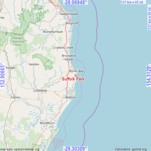
Suffolk Park GPS coordinates[2]
28° 41' 17.16" South, 153° 36' 35.172" East
| Map corner | latitude | longitude |
|---|---|---|
| Upper-left | -28.06948°, | 152.90665° |
| Center: | -28.6881°, | 153.60977° |
| Lower-right: | -29.30309°, | 154.3129° |
| Map W x H: | 137.2×137.2 km | = 85.3×85.3mi |
| max Lat: | -10.58257° ⇑25.9% North |
| Suffolk Park: | -28.6881° |
| min Lat: | ⇓74.1% South -43.31423° |
| min Long | Suffolk Park | max Long |
| 113.53327° | 153.60977° | 153.61246° |
| W 100%⇐ | ⇒0% E |
Elevation
Elevation of Suffolk Park is 10 m = 33 ft, and this is 112 m = 367 ft below average elevation for this country.
| Max E: |
1715 m = 5627 ft | 88.3% |
| Avg. | 122 m = 400 ft | |
| Suffolk Park | 10 m = 33 ft | |
Min E: |
-2 m = -7 ft | 11.7% |
See also: Australia elevation on elevation.city.
Geographical zone
Suffolk Park is located in South temperate zone (between Tropic of Capricorn and the Antarctic Circle). Distance of this Southern Tropic circle is 583.9 km =362.8 mi to North.| Distance of | km | miles | from Suffolk Park |
|---|---|---|---|
| Equator | 3189.8 | 1982 | to North |
| Tropic Capricorn | 583.9 | 362.8 | to North |
| Antarctic Circle | 4211.4 | 2616.8 | to South |
| South Pole | 6817.2 | 4236 | to South |


Nearby cities:
15 places around Suffolk Park: (largest is in red/bold)
• Ballina
20 km =12.4 mi,  192°
192°
• Bangalow
8.6 km =5.3 mi,  271°
271°
• Brunswick Heads
17.6 km =10.9 mi,  339°
339°
• Byron Bay
4.3 km =2.7 mi,  3°
3°
• Clunes
20.3 km =12.6 mi,  256°
256°
• Cumbalum
16.9 km =10.5 mi,  207°
207°
• East Ballina
18.9 km =11.7 mi, 186°
• Ewingsdale
8 km =5 mi,  316°
316°
• Federal
16.1 km =10 mi,  285°
285°
• Lennox Head
11.6 km =7.2 mi, 188°
• Mullumbimby
18.5 km =11.5 mi, 324°
• Myocum
14.4 km =8.9 mi, 315°
• Skennars Head
15.7 km =9.8 mi,  182°
182°
• Tintenbar
15 km =9.3 mi, 214°
• West Ballina
20.7 km =12.9 mi,  201°
201°
Sources, notices
• [Note1] Compared only with cities in Australia existing in our database
• [Src1] Map data: © OpenStreetMap contributors (CC-BY-SA)
• [Src2] Other city data from geonames.org with taken over terms of usage.
• [Src3] Geographical zone / Annual Mean Temperature by Robert A. Rohde @ Wikipedia
