Federal geodata
Federal (New South Wales) is a populated place; located in Australia in Australia/Sydney (GMT+11) time zone. With population of 661 people, there are 4404 cities with bigger population in this country. Compared to other cities in Australia, 74.3% of cities are located further ↓South; 99.2% of cities are located further ←West and 80.7% of cities have lower elevation than Federal. Note1


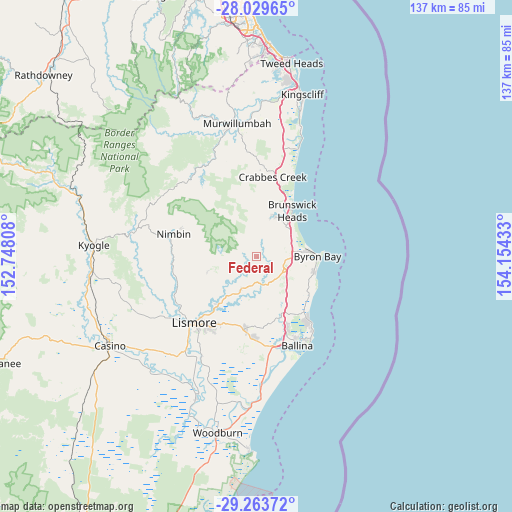
Federal GPS coordinates[2]
28° 38' 54.6" South, 153° 27' 4.32" East
| Map corner | latitude | longitude |
|---|---|---|
| Upper-left | -28.02965°, | 152.74808° |
| Center: | -28.6485°, | 153.4512° |
| Lower-right: | -29.26372°, | 154.15433° |
| Map W x H: | 137.2×137.2 km | = 85.3×85.3mi |
| max Lat: | -10.58257° ⇑25.7% North |
| Federal: | -28.6485° |
| min Lat: | ⇓74.3% South -43.31423° |
| min Long | Federal | max Long |
| 113.53327° | 153.4512° | 153.61246° |
| W 99.2%⇐ | ⇒0.8% E |
Elevation
Elevation of Federal is 189 m = 620 ft, and this is 67 m = 220 ft above average elevation for this country.
| Max E: |
1715 m = 5627 ft | 19.3% |
| Federal | 189 m 620 ft | |
| Avg. | 122 m = 400 ft | |
Min E: |
-2 m = -7 ft | 80.7% |
See also: Australia elevation on elevation.city.
Geographical zone
Federal is located in South temperate zone (between Tropic of Capricorn and the Antarctic Circle). Distance of this Southern Tropic circle is 579.5 km =360.1 mi to North.| Distance of | km | miles | from Federal |
|---|---|---|---|
| Equator | 3185.4 | 1979.3 | to North |
| Tropic Capricorn | 579.5 | 360.1 | to North |
| Antarctic Circle | 4215.8 | 2619.6 | to South |
| South Pole | 6821.6 | 4238.7 | to South |


Nearby cities:
15 places around Federal: (largest is in red/bold)
• Bangalow
8 km =5 mi,  121°
121°
• Brunswick Heads
15.2 km =9.4 mi,  37°
37°
• Byron Bay
15.7 km =9.8 mi,  90°
90°
• Clunes
10.1 km =6.3 mi,  204°
204°
• Dunoon
13.6 km =8.5 mi,  252°
252°
• Ewingsdale
10.1 km =6.3 mi,  82°
82°
• McLeans Ridges
18.1 km =11.2 mi, 201°
• Modanville
16.4 km =10.2 mi,  243°
243°
• Mullumbimby
11.7 km =7.3 mi,  23°
23°
• Mullumbimby Creek
11.4 km =7.1 mi,  352°
352°
• Myocum
7.9 km =4.9 mi, 42°
• Ocean Shores
17.6 km =10.9 mi,  28°
28°
• South Golden Beach
19.2 km =11.9 mi, 29°
• Suffolk Park
16.1 km =10 mi,  105°
105°
• Tintenbar
18.1 km =11.2 mi,  157°
157°
Sources, notices
• [Note1] Compared only with cities in Australia existing in our database
• [Src1] Map data: © OpenStreetMap contributors (CC-BY-SA)
• [Src2] Other city data from geonames.org with taken over terms of usage.
• [Src3] Geographical zone / Annual Mean Temperature by Robert A. Rohde @ Wikipedia
