Ewingsdale geodata
Ewingsdale (New South Wales) is a populated place; located in Australia in Australia/Sydney (GMT+11) time zone. With population of 869 people, there are 4020 cities with bigger population in this country. Compared to other cities in Australia, 74.3% of cities are located further ↓South; 99.7% of cities are located further ←West and 53.1% of cities have higher elevation than Ewingsdale. Note1


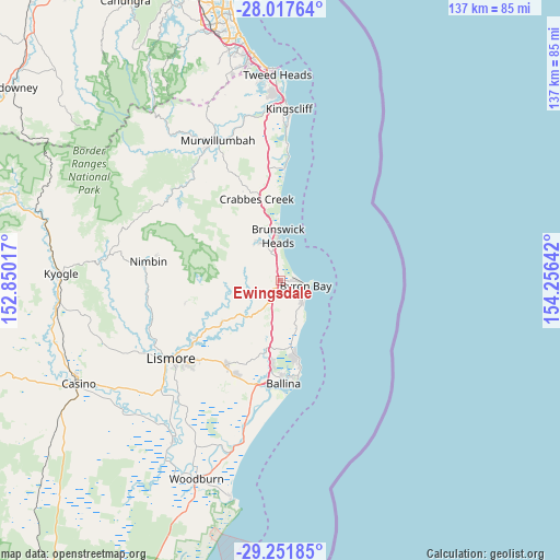
Ewingsdale GPS coordinates[2]
28° 38' 11.616" South, 153° 33' 11.844" East
| Map corner | latitude | longitude |
|---|---|---|
| Upper-left | -28.01764°, | 152.85017° |
| Center: | -28.63656°, | 153.55329° |
| Lower-right: | -29.25185°, | 154.25642° |
| Map W x H: | 137.2×137.2 km | = 85.3×85.3mi |
| max Lat: | -10.58257° ⇑25.7% North |
| Ewingsdale: | -28.63656° |
| min Lat: | ⇓74.3% South -43.31423° |
| min Long | Ewingsdale | max Long |
| 113.53327° | 153.55329° | 153.61246° |
| W 99.7%⇐ | ⇒0.3% E |
Elevation
Elevation of Ewingsdale is 41 m = 135 ft, and this is 81 m = 266 ft below average elevation for this country.
| Max E: |
1715 m = 5627 ft | 53.1% |
| Avg. | 122 m = 400 ft | |
| Ewingsdale | 41 m = 135 ft | |
Min E: |
-2 m = -7 ft | 46.9% |
See also: Australia elevation on elevation.city.
Geographical zone
Ewingsdale is located in South temperate zone (between Tropic of Capricorn and the Antarctic Circle). Distance of this Southern Tropic circle is 578.2 km =359.3 mi to North.| Distance of | km | miles | from Ewingsdale |
|---|---|---|---|
| Equator | 3184.1 | 1978.5 | to North |
| Tropic Capricorn | 578.2 | 359.3 | to North |
| Antarctic Circle | 4217.1 | 2620.4 | to South |
| South Pole | 6823 | 4239.6 | to South |


Nearby cities:
15 places around Ewingsdale: (largest is in red/bold)
• Bangalow
6.3 km =3.9 mi,  209°
209°
• Brunswick Heads
10.8 km =6.7 mi,  356°
356°
• Byron Bay
6 km =3.7 mi,  104°
104°
• Clunes
17.7 km =11 mi,  233°
233°
• Cumbalum
20.8 km =12.9 mi,  186°
186°
• Federal
10.1 km =6.3 mi,  262°
262°
• Lennox Head
17.6 km =10.9 mi,  167°
167°
• Mullumbimby
10.7 km =6.6 mi,  330°
330°
• Mullumbimby Creek
15.2 km =9.4 mi,  310°
310°
• Myocum
6.5 km =4 mi, 314°
• Ocean Shores
14.2 km =8.8 mi,  353°
353°
• Skennars Head
21.9 km =13.6 mi, 167°
• South Golden Beach
15.4 km =9.6 mi, 357°
• Suffolk Park
8 km =5 mi,  136°
136°
• Tintenbar
18.3 km =11.4 mi, 189°
Sources, notices
• [Note1] Compared only with cities in Australia existing in our database
• [Src1] Map data: © OpenStreetMap contributors (CC-BY-SA)
• [Src2] Other city data from geonames.org with taken over terms of usage.
• [Src3] Geographical zone / Annual Mean Temperature by Robert A. Rohde @ Wikipedia
