Myocum geodata
Myocum (New South Wales) is a section of populated place; located in Australia in Australia/Sydney (GMT+11) time zone. With population of 986 people, there are 3849 cities with bigger population in this country. Compared to other cities in Australia, 74.4% of cities are located further ↓South; 99.4% of cities are located further ←West and 60% of cities have higher elevation than Myocum. Note1


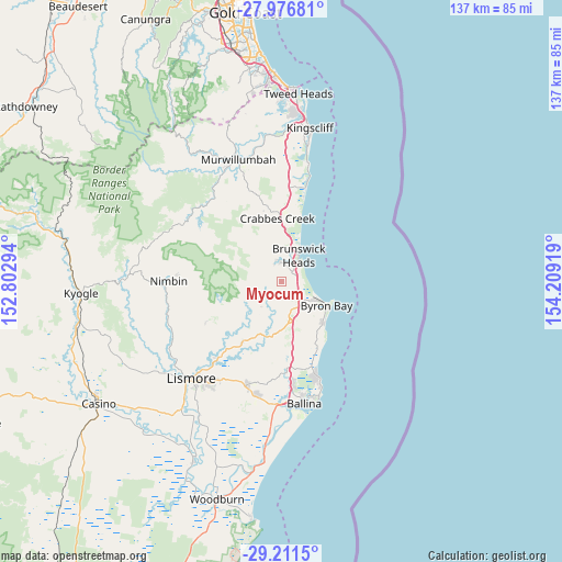
Myocum GPS coordinates[2]
28° 35' 45.492" South, 153° 30' 21.816" East
| Map corner | latitude | longitude |
|---|---|---|
| Upper-left | -27.97681°, | 152.80294° |
| Center: | -28.59597°, | 153.50606° |
| Lower-right: | -29.2115°, | 154.20919° |
| Map W x H: | 137.3×137.3 km | = 85.3×85.3mi |
| max Lat: | -10.58257° ⇑25.6% North |
| Myocum: | -28.59597° |
| min Lat: | ⇓74.4% South -43.31423° |
| min Long | Myocum | max Long |
| 113.53327° | 153.50606° | 153.61246° |
| W 99.4%⇐ | ⇒0.59999999999999% E |
Elevation
Elevation of Myocum is 32 m = 105 ft, and this is 90 m = 295 ft below average elevation for this country.
| Max E: |
1715 m = 5627 ft | 60% |
| Avg. | 122 m = 400 ft | |
| Myocum | 32 m = 105 ft | |
Min E: |
-2 m = -7 ft | 40% |
See also: Australia elevation on elevation.city.
Geographical zone
Myocum is located in South temperate zone (between Tropic of Capricorn and the Antarctic Circle). Distance of this Southern Tropic circle is 573.7 km =356.5 mi to North.| Distance of | km | miles | from Myocum |
|---|---|---|---|
| Equator | 3179.6 | 1975.7 | to North |
| Tropic Capricorn | 573.7 | 356.5 | to North |
| Antarctic Circle | 4221.6 | 2623.2 | to South |
| South Pole | 6827.5 | 4242.4 | to South |


Nearby cities:
15 places around Myocum: (largest is in red/bold)
• Bangalow
10.2 km =6.3 mi,  171°
171°
• Brunswick Heads
7.3 km =4.5 mi,  31°
31°
• Burringbar
18.1 km =11.2 mi,  349°
349°
• Byron Bay
12 km =7.5 mi,  119°
119°
• Clunes
17.9 km =11.1 mi,  212°
212°
• Dunoon
20.9 km =13 mi,  241°
241°
• Ewingsdale
6.5 km =4 mi,  134°
134°
• Federal
7.9 km =4.9 mi,  222°
222°
• Mullumbimby
4.9 km =3 mi, 352°
• Mullumbimby Creek
8.8 km =5.5 mi,  308°
308°
• Ocean Shores
10.1 km =6.3 mi,  17°
17°
• South Golden Beach
11.6 km =7.2 mi, 20°
• Stokers Siding
22.7 km =14.1 mi,  336°
336°
• Suffolk Park
14.4 km =8.9 mi,  135°
135°
• Tintenbar
22.6 km =14 mi,  176°
176°
Sources, notices
• [Note1] Compared only with cities in Australia existing in our database
• [Src1] Map data: © OpenStreetMap contributors (CC-BY-SA)
• [Src2] Other city data from geonames.org with taken over terms of usage.
• [Src3] Geographical zone / Annual Mean Temperature by Robert A. Rohde @ Wikipedia
