Mangrove Mountain geodata
Mangrove Mountain (New South Wales) is a section of populated place; located in Australia in Australia/Sydney (GMT+11) time zone. With population of 702 people, there are 4324 cities with bigger population in this country. Compared to other cities in Australia, 55.4% of cities are located further ↓South; 73.1% of cities are located further ←West and 87.1% of cities have lower elevation than Mangrove Mountain. Note1


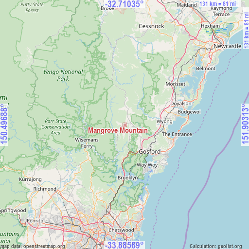
Mangrove Mountain GPS coordinates[2]
33° 18' 0" South, 151° 12' 0" East
| Map corner | latitude | longitude |
|---|---|---|
| Upper-left | -32.71035°, | 150.49688° |
| Center: | -33.3°, | 151.2° |
| Lower-right: | -33.88569°, | 151.90313° |
| Map W x H: | 130.7×130.7 km | = 81.2×81.2mi |
| max Lat: | -10.58257° ⇑44.6% North |
| Mangrove Mountain: | -33.3° |
| min Lat: | ⇓55.4% South -43.31423° |
| min Long | Mangrove Mounta | max Long |
| 113.53327° | 151.2° | 153.61246° |
| W 73.1%⇐ | ⇒26.9% E |
Elevation
Elevation of Mangrove Mountain is 288 m = 945 ft, and this is 166 m = 545 ft above average elevation for this country.
| Max E: |
1715 m = 5627 ft | 12.9% |
| Mangrove Mountain | 288 m 945 ft | |
| Avg. | 122 m = 400 ft | |
Min E: |
-2 m = -7 ft | 87.1% |
See also: Australia elevation on elevation.city.
Geographical zone
Mangrove Mountain is located in South temperate zone (between Tropic of Capricorn and the Antarctic Circle). Distance of this Southern Tropic circle is 1096.7 km =681.5 mi to North.| Distance of | km | miles | from Mangrove Mountain |
|---|---|---|---|
| Equator | 3702.6 | 2300.7 | to North |
| Tropic Capricorn | 1096.7 | 681.5 | to North |
| Antarctic Circle | 3698.6 | 2298.2 | to South |
| South Pole | 6304.4 | 3917.4 | to South |


Nearby cities:
15 places around Mangrove Mountain: (largest is in red/bold)
• Fountaindale
19.4 km =12.1 mi,  105°
105°
• Gosford
19.2 km =11.9 mi,  135°
135°
• Kariong
17.8 km =11.1 mi,  150°
150°
• Kulnura
10.8 km =6.7 mi,  348°
348°
• Lisarow
18 km =11.2 mi,  120°
120°
• Mardi
18.7 km =11.6 mi,  87°
87°
• Narara
16.5 km =10.3 mi,  130°
130°
• Niagara Park
16.2 km =10.1 mi, 121°
• North Gosford
18.9 km =11.7 mi, 131°
• Ourimbah
12.2 km =7.6 mi,  97°
97°
• Point Clare
19.9 km =12.4 mi, 143°
• Somersby
10.7 km =6.6 mi, 133°
• Tascott
19.8 km =12.3 mi, 147°
• West Gosford
17.7 km =11 mi, 142°
• Wyoming
19 km =11.8 mi, 127°
Sources, notices
• [Note1] Compared only with cities in Australia existing in our database
• [Src1] Map data: © OpenStreetMap contributors (CC-BY-SA)
• [Src2] Other city data from geonames.org with taken over terms of usage.
• [Src3] Geographical zone / Annual Mean Temperature by Robert A. Rohde @ Wikipedia
