Kulnura geodata
Kulnura (New South Wales) is a section of populated place; located in Australia in Australia/Sydney (GMT+11) time zone. With population of 615 people, there are 4532 cities with bigger population in this country. Compared to other cities in Australia, 56.1% of cities are located further ↓South; 72.4% of cities are located further ←West and 85.5% of cities have lower elevation than Kulnura. Note1


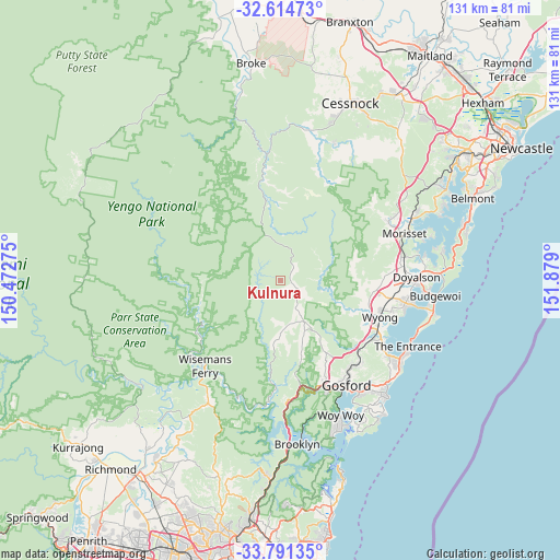
Kulnura GPS coordinates[2]
33° 12' 18.072" South, 151° 10' 33.132" East
| Map corner | latitude | longitude |
|---|---|---|
| Upper-left | -32.61473°, | 150.47275° |
| Center: | -33.20502°, | 151.17587° |
| Lower-right: | -33.79135°, | 151.879° |
| Map W x H: | 130.8×130.8 km | = 81.3×81.3mi |
| max Lat: | -10.58257° ⇑43.9% North |
| Kulnura: | -33.20502° |
| min Lat: | ⇓56.1% South -43.31423° |
| min Long | Kulnura | max Long |
| 113.53327° | 151.17587° | 153.61246° |
| W 72.4%⇐ | ⇒27.6% E |
Elevation
Elevation of Kulnura is 256 m = 840 ft, and this is 134 m = 440 ft above average elevation for this country.
| Max E: |
1715 m = 5627 ft | 14.5% |
| Kulnura | 256 m 840 ft | |
| Avg. | 122 m = 400 ft | |
Min E: |
-2 m = -7 ft | 85.5% |
See also: Australia elevation on elevation.city.
Geographical zone
Kulnura is located in South temperate zone (between Tropic of Capricorn and the Antarctic Circle). Distance of this Southern Tropic circle is 1086.1 km =674.9 mi to North.| Distance of | km | miles | from Kulnura |
|---|---|---|---|
| Equator | 3692.1 | 2294.2 | to North |
| Tropic Capricorn | 1086.1 | 674.9 | to North |
| Antarctic Circle | 3709.1 | 2304.7 | to South |
| South Pole | 6315 | 3924 | to South |


Nearby cities:
15 places around Kulnura: (largest is in red/bold)
• Chittaway Bay
27.3 km =17 mi,  120°
120°
• Fountaindale
26.3 km =16.3 mi,  127°
127°
• Jilliby
22.5 km =14 mi,  95°
95°
• Lisarow
26.6 km =16.5 mi,  138°
138°
• Mangrove Mountain
10.8 km =6.7 mi,  168°
168°
• Mardi
23.2 km =14.4 mi, 115°
• Narara
25.9 km =16.1 mi,  145°
145°
• Niagara Park
24.9 km =15.5 mi, 139°
• Ourimbah
18.8 km =11.7 mi, 130°
• Somersby
20.6 km =12.8 mi, 150°
• Tuggerah
26.1 km =16.2 mi, 115°
• Warnervale
26.1 km =16.2 mi, 100°
• Watanobbi
24 km =14.9 mi,  106°
106°
• West Gosford
27.8 km =17.3 mi, 151°
• Wyong
24.6 km =15.3 mi, 110°
Sources, notices
• [Note1] Compared only with cities in Australia existing in our database
• [Src1] Map data: © OpenStreetMap contributors (CC-BY-SA)
• [Src2] Other city data from geonames.org with taken over terms of usage.
• [Src3] Geographical zone / Annual Mean Temperature by Robert A. Rohde @ Wikipedia
