Koo-Wee-Rup geodata
Koo-Wee-Rup (Victoria) is a section of populated place; located in Australia in Australia/Melbourne (GMT+11) time zone. With population of 3,079 people, there are 2204 cities with bigger population in this country. Compared to other cities in Australia, 94% of cities are located further ↑North; 59.7% of cities are located further →East and 91.8% of cities have higher elevation than Koo-Wee-Rup. Note1


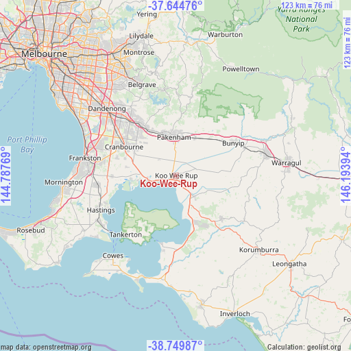
Koo-Wee-Rup GPS coordinates[2]
38° 11' 57.876" South, 145° 29' 26.916" East
| Map corner | latitude | longitude |
|---|---|---|
| Upper-left | -37.64476°, | 144.78769° |
| Center: | -38.19941°, | 145.49081° |
| Lower-right: | -38.74987°, | 146.19394° |
| Map W x H: | 122.9×122.9 km | = 76.4×76.4mi |
| max Lat: | -10.58257° ⇑94% North |
| Koo-Wee-Rup: | -38.19941° |
| min Lat: | ⇓6% South -43.31423° |
| min Long | Koo-Wee-Rup | max Long |
| 113.53327° | 145.49081° | 153.61246° |
| W 40.3%⇐ | ⇒59.7% E |
Elevation
Elevation of Koo-Wee-Rup is 8 m = 26 ft, and this is 114 m = 374 ft below average elevation for this country.
| Max E: |
1715 m = 5627 ft | 91.8% |
| Avg. | 122 m = 400 ft | |
| Koo-Wee-Rup | 8 m = 26 ft | |
Min E: |
-2 m = -7 ft | 8.2% |
See also: Australia elevation on elevation.city.
Geographical zone
Koo-Wee-Rup is located in South temperate zone (between Tropic of Capricorn and the Antarctic Circle). Distance of this Southern Tropic circle is 1641.5 km =1020 mi to North.| Distance of | km | miles | from Koo-Wee-Rup |
|---|---|---|---|
| Equator | 4247.4 | 2639.2 | to North |
| Tropic Capricorn | 1641.5 | 1020 | to North |
| Antarctic Circle | 3153.8 | 1959.7 | to South |
| South Pole | 5759.7 | 3578.9 | to South |


Nearby cities:
15 places around Koo-Wee-Rup: (largest is in red/bold)
• Beaconsfield
19.8 km =12.3 mi,  326°
326°
• Blind Bight
13.5 km =8.4 mi,  262°
262°
• Cannons Creek
15.4 km =9.6 mi, 264°
• Clyde
15.6 km =9.7 mi,  298°
298°
• Clyde North
16.6 km =10.3 mi, 303°
• Cranbourne East
19.3 km =12 mi, 299°
• Devon Meadows
17.1 km =10.6 mi,  282°
282°
• Garfield
20.2 km =12.6 mi,  52°
52°
• Junction Village
18.3 km =11.4 mi,  292°
292°
• Lang Lang
9.7 km =6 mi,  139°
139°
• Nar Nar Goon
14.7 km =9.1 mi,  28°
28°
• Officer
17.1 km =10.6 mi,  335°
335°
• Pakenham
14.4 km =8.9 mi,  354°
354°
• Tooradin
9.6 km =6 mi, 259°
• Warneet
16.1 km =10 mi, 260°
Sources, notices
• [Note1] Compared only with cities in Australia existing in our database
• [Src1] Map data: © OpenStreetMap contributors (CC-BY-SA)
• [Src2] Other city data from geonames.org with taken over terms of usage.
• [Src3] Geographical zone / Annual Mean Temperature by Robert A. Rohde @ Wikipedia
