Lang Lang geodata
Lang Lang (Victoria) is a section of populated place; located in Australia in Australia/Melbourne (GMT+11) time zone. With population of 1,543 people, there are 3245 cities with bigger population in this country. Compared to other cities in Australia, 94.6% of cities are located further ↑North; 59.3% of cities are located further →East and 76.1% of cities have higher elevation than Lang Lang. Note1


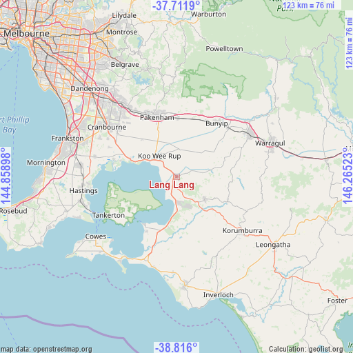
Lang Lang GPS coordinates[2]
38° 15' 57.78" South, 145° 33' 43.56" East
| Map corner | latitude | longitude |
|---|---|---|
| Upper-left | -37.7119°, | 144.85898° |
| Center: | -38.26605°, | 145.5621° |
| Lower-right: | -38.816°, | 146.26523° |
| Map W x H: | 122.8×122.8 km | = 76.3×76.3mi |
| max Lat: | -10.58257° ⇑94.6% North |
| Lang Lang: | -38.26605° |
| min Lat: | ⇓5.4% South -43.31423° |
| min Long | Lang Lang | max Long |
| 113.53327° | 145.5621° | 153.61246° |
| W 40.7%⇐ | ⇒59.3% E |
Elevation
Elevation of Lang Lang is 18 m = 59 ft, and this is 104 m = 341 ft below average elevation for this country.
| Max E: |
1715 m = 5627 ft | 76.1% |
| Avg. | 122 m = 400 ft | |
| Lang Lang | 18 m = 59 ft | |
Min E: |
-2 m = -7 ft | 23.9% |
See also: Australia elevation on elevation.city.
Geographical zone
Lang Lang is located in South temperate zone (between Tropic of Capricorn and the Antarctic Circle). Distance of this Southern Tropic circle is 1648.9 km =1024.6 mi to North.| Distance of | km | miles | from Lang Lang |
|---|---|---|---|
| Equator | 4254.8 | 2643.8 | to North |
| Tropic Capricorn | 1648.9 | 1024.6 | to North |
| Antarctic Circle | 3146.4 | 1955.1 | to South |
| South Pole | 5752.3 | 3574.3 | to South |


Nearby cities:
15 places around Lang Lang: (largest is in red/bold)
• Blind Bight
20.4 km =12.7 mi,  286°
286°
• Bunyip
23 km =14.3 mi,  35°
35°
• Cannons Creek
22.4 km =13.9 mi, 285°
• Corinella
20.2 km =12.6 mi,  215°
215°
• Coronet Bay
21.8 km =13.5 mi,  207°
207°
• Garfield
21.9 km =13.6 mi,  26°
26°
• Grantville
15.9 km =9.9 mi,  190°
190°
• Koo-Wee-Rup
9.7 km =6 mi,  319°
319°
• Loch
17.1 km =10.6 mi,  131°
131°
• Nar Nar Goon
20.4 km =12.7 mi,  1°
1°
• Nyora
12.2 km =7.6 mi, 127°
• Pakenham
23.1 km =14.4 mi,  340°
340°
• Poowong
19.6 km =12.2 mi,  115°
115°
• Tooradin
16.6 km =10.3 mi, 290°
• Warneet
22.6 km =14 mi,  281°
281°
Sources, notices
• [Note1] Compared only with cities in Australia existing in our database
• [Src1] Map data: © OpenStreetMap contributors (CC-BY-SA)
• [Src2] Other city data from geonames.org with taken over terms of usage.
• [Src3] Geographical zone / Annual Mean Temperature by Robert A. Rohde @ Wikipedia
