Tapitallee geodata
Tapitallee (New South Wales) is a populated place; located in Australia in Australia/Sydney (GMT+11) time zone. With population of 602 people, there are 4563 cities with bigger population in this country. Compared to other cities in Australia, 66.2% of cities are located further ↑North; 59.1% of cities are located further ←West and 63% of cities have lower elevation than Tapitallee. Note1


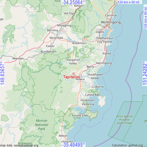
Tapitallee GPS coordinates[2]
34° 49' 47.352" South, 150° 32' 22.884" East
| Map corner | latitude | longitude |
|---|---|---|
| Upper-left | -34.25064°, | 149.83657° |
| Center: | -34.82982°, | 150.53969° |
| Lower-right: | -35.40495°, | 151.24282° |
| Map W x H: | 128.3×128.3 km | = 79.7×79.7mi |
| max Lat: | -10.58257° ⇑66.2% North |
| Tapitallee: | -34.82982° |
| min Lat: | ⇓33.8% South -43.31423° |
| min Long | Tapitallee | max Long |
| 113.53327° | 150.53969° | 153.61246° |
| W 59.1%⇐ | ⇒40.9% E |
Elevation
Elevation of Tapitallee is 73 m = 240 ft, and this is 49 m = 161 ft below average elevation for this country.
| Max E: |
1715 m = 5627 ft | 37% |
| Avg. | 122 m = 400 ft | |
| Tapitallee | 73 m = 240 ft | |
Min E: |
-2 m = -7 ft | 63% |
See also: Australia elevation on elevation.city.
Geographical zone
Tapitallee is located in South temperate zone (between Tropic of Capricorn and the Antarctic Circle). Distance of this Southern Tropic circle is 1266.8 km =787.2 mi to North.| Distance of | km | miles | from Tapitallee |
|---|---|---|---|
| Equator | 3872.7 | 2406.4 | to North |
| Tropic Capricorn | 1266.8 | 787.2 | to North |
| Antarctic Circle | 3528.5 | 2192.5 | to South |
| South Pole | 6134.3 | 3811.7 | to South |


Nearby cities:
15 places around Tapitallee: (largest is in red/bold)
• Berry
15.4 km =9.6 mi,  66°
66°
• Bomaderry
6.9 km =4.3 mi,  108°
108°
• Cambewarra Village
1.9 km =1.2 mi, 68°
• Culburra Beach
22.7 km =14.1 mi,  118°
118°
• Falls Creek
16.2 km =10.1 mi,  160°
160°
• Greenwell Point
19.5 km =12.1 mi, 116°
• Kangaroo Valley
10.2 km =6.3 mi,  358°
358°
• North Nowra
4.5 km =2.8 mi,  134°
134°
• Nowra
8.2 km =5.1 mi,  137°
137°
• Nowra Hill
11.4 km =7.1 mi, 164°
• Orient Point
21.1 km =13.1 mi, 114°
• Shoalhaven Heads
18.9 km =11.7 mi,  97°
97°
• South Nowra
9.8 km =6.1 mi,  146°
146°
• West Nowra
7.4 km =4.6 mi, 147°
• Worrigee
11.6 km =7.2 mi, 132°
Sources, notices
• [Note1] Compared only with cities in Australia existing in our database
• [Src1] Map data: © OpenStreetMap contributors (CC-BY-SA)
• [Src2] Other city data from geonames.org with taken over terms of usage.
• [Src3] Geographical zone / Annual Mean Temperature by Robert A. Rohde @ Wikipedia
