Imbil geodata
Imbil (Queensland) is a populated place; located in Australia in Australia/Brisbane (GMT+10) time zone. With population of 958 people, there are 3888 cities with bigger population in this country. Compared to other cities in Australia, 87.7% of cities are located further ↓South; 85.6% of cities are located further ←West and 67.3% of cities have lower elevation than Imbil. Note1


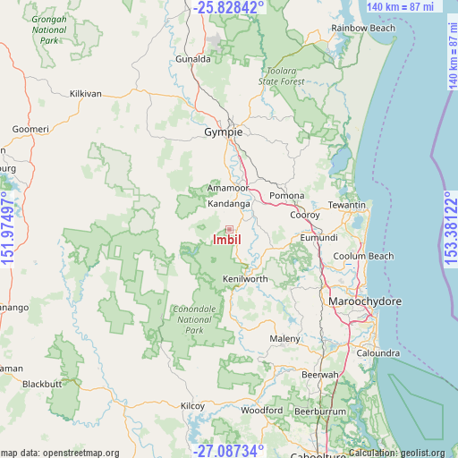
Imbil GPS coordinates[2]
26° 27' 34.56" South, 152° 40' 41.124" East
| Map corner | latitude | longitude |
|---|---|---|
| Upper-left | -25.82842°, | 151.97497° |
| Center: | -26.4596°, | 152.67809° |
| Lower-right: | -27.08734°, | 153.38122° |
| Map W x H: | 140×140 km | = 87×87mi |
| max Lat: | -10.58257° ⇑12.3% North |
| Imbil: | -26.4596° |
| min Lat: | ⇓87.7% South -43.31423° |
| min Long | Imbil | max Long |
| 113.53327° | 152.67809° | 153.61246° |
| W 85.6%⇐ | ⇒14.4% E |
Elevation
Elevation of Imbil is 90 m = 295 ft, and this is 32 m = 105 ft below average elevation for this country.
| Max E: |
1715 m = 5627 ft | 32.7% |
| Avg. | 122 m = 400 ft | |
| Imbil | 90 m = 295 ft | |
Min E: |
-2 m = -7 ft | 67.3% |
See also: Australia elevation on elevation.city.
Geographical zone
Imbil is located in South temperate zone (between Tropic of Capricorn and the Antarctic Circle). Distance of this Southern Tropic circle is 336.1 km =208.8 mi to North.| Distance of | km | miles | from Imbil |
|---|---|---|---|
| Equator | 2942 | 1828.1 | to North |
| Tropic Capricorn | 336.1 | 208.8 | to North |
| Antarctic Circle | 4459.1 | 2770.8 | to South |
| South Pole | 7065 | 4390 | to South |


Nearby cities:
15 places around Imbil: (largest is in red/bold)
• Amamoor
12.3 km =7.6 mi,  0°
0°
• Belli Park
15.2 km =9.4 mi,  110°
110°
• Black Mountain
20.8 km =12.9 mi,  71°
71°
• Cooran
19.8 km =12.3 mi,  46°
46°
• Cooroy
23.7 km =14.7 mi,  78°
78°
• Eerwah Vale
23.3 km =14.5 mi,  95°
95°
• Jones Hill
25.6 km =15.9 mi,  357°
357°
• Kandanga
7.4 km =4.6 mi, 358°
• Kenilworth
16 km =9.9 mi,  161°
161°
• Lake Macdonald
26.6 km =16.5 mi, 71°
• Mapleton
26.3 km =16.3 mi,  134°
134°
• Mothar Mountain
25.2 km =15.7 mi,  22°
22°
• Pie Creek
26.5 km =16.5 mi,  344°
344°
• Pomona
20.5 km =12.7 mi,  59°
59°
• The Dawn
24.2 km =15 mi, 0°
Sources, notices
• [Note1] Compared only with cities in Australia existing in our database
• [Src1] Map data: © OpenStreetMap contributors (CC-BY-SA)
• [Src2] Other city data from geonames.org with taken over terms of usage.
• [Src3] Geographical zone / Annual Mean Temperature by Robert A. Rohde @ Wikipedia
