Kenilworth geodata
Kenilworth (Queensland) is a section of populated place; located in Australia in Australia/Brisbane (GMT+10) time zone. With population of 598 people, there are 4575 cities with bigger population in this country. Compared to other cities in Australia, 87.2% of cities are located further ↓South; 86.1% of cities are located further ←West and 69.8% of cities have lower elevation than Kenilworth. Note1


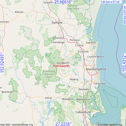
Kenilworth GPS coordinates[2]
26° 35' 47.832" South, 152° 43' 41.052" East
| Map corner | latitude | longitude |
|---|---|---|
| Upper-left | -25.96618°, | 152.02495° |
| Center: | -26.59662°, | 152.72807° |
| Lower-right: | -27.2236°, | 153.4312° |
| Map W x H: | 139.8×139.8 km | = 86.9×86.9mi |
| max Lat: | -10.58257° ⇑12.8% North |
| Kenilworth: | -26.59662° |
| min Lat: | ⇓87.2% South -43.31423° |
| min Long | Kenilworth | max Long |
| 113.53327° | 152.72807° | 153.61246° |
| W 86.1%⇐ | ⇒13.9% E |
Elevation
Elevation of Kenilworth is 102 m = 335 ft, and this is 20 m = 66 ft below average elevation for this country.
| Max E: |
1715 m = 5627 ft | 30.2% |
| Avg. | 122 m = 400 ft | |
| Kenilworth | 102 m = 335 ft | |
Min E: |
-2 m = -7 ft | 69.8% |
See also: Australia elevation on elevation.city.
Geographical zone
Kenilworth is located in South temperate zone (between Tropic of Capricorn and the Antarctic Circle). Distance of this Southern Tropic circle is 351.3 km =218.3 mi to North.| Distance of | km | miles | from Kenilworth |
|---|---|---|---|
| Equator | 2957.3 | 1837.6 | to North |
| Tropic Capricorn | 351.3 | 218.3 | to North |
| Antarctic Circle | 4443.9 | 2761.3 | to South |
| South Pole | 7049.8 | 4380.5 | to South |


Nearby cities:
15 places around Kenilworth: (largest is in red/bold)
• Belli Park
13.5 km =8.4 mi,  43°
43°
• Burnside
21.5 km =13.4 mi,  100°
100°
• Conondale
15.6 km =9.7 mi,  182°
182°
• Dulong
18.2 km =11.3 mi, 103°
• Flaxton
15.1 km =9.4 mi,  116°
116°
• Hunchy
20.4 km =12.7 mi, 117°
• Imbil
16 km =9.9 mi,  341°
341°
• Kureelpa
16.2 km =10.1 mi,  93°
93°
• Maleny
21.8 km =13.5 mi,  146°
146°
• Mapleton
14.2 km =8.8 mi, 102°
• Montville
18.2 km =11.3 mi, 121°
• North Maleny
21.6 km =13.4 mi,  143°
143°
• Reesville
19.1 km =11.9 mi,  161°
161°
• West Woombye
21.1 km =13.1 mi,  111°
111°
• Witta
14.5 km =9 mi, 142°
Sources, notices
• [Note1] Compared only with cities in Australia existing in our database
• [Src1] Map data: © OpenStreetMap contributors (CC-BY-SA)
• [Src2] Other city data from geonames.org with taken over terms of usage.
• [Src3] Geographical zone / Annual Mean Temperature by Robert A. Rohde @ Wikipedia
