Lancefield geodata
Lancefield (Victoria) is a populated place; located in Australia in Australia/Melbourne (GMT+11) time zone. With population of 2,439 people, there are 2607 cities with bigger population in this country. Compared to other cities in Australia, 82.1% of cities are located further ↑North; 69.4% of cities are located further →East and 93.2% of cities have lower elevation than Lancefield. Note1


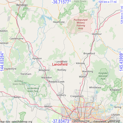
Lancefield GPS coordinates[2]
37° 16' 38.388" South, 144° 44' 9.456" East
| Map corner | latitude | longitude |
|---|---|---|
| Upper-left | -36.71577°, | 144.03284° |
| Center: | -37.27733°, | 144.73596° |
| Lower-right: | -37.83473°, | 145.43909° |
| Map W x H: | 124.4×124.4 km | = 77.3×77.3mi |
| max Lat: | -10.58257° ⇑82.1% North |
| Lancefield: | -37.27733° |
| min Lat: | ⇓17.9% South -43.31423° |
| min Long | Lancefield | max Long |
| 113.53327° | 144.73596° | 153.61246° |
| W 30.6%⇐ | ⇒69.4% E |
Elevation
Elevation of Lancefield is 480 m = 1575 ft, and this is 358 m = 1175 ft above average elevation for this country.
| Max E: |
1715 m = 5627 ft | 6.8% |
| Lancefield | 480 m 1575 ft | |
| Avg. | 122 m = 400 ft | |
Min E: |
-2 m = -7 ft | 93.2% |
See also: Australia elevation on elevation.city.
Geographical zone
Lancefield is located in South temperate zone (between Tropic of Capricorn and the Antarctic Circle). Distance of this Southern Tropic circle is 1538.9 km =956.2 mi to North.| Distance of | km | miles | from Lancefield |
|---|---|---|---|
| Equator | 4144.9 | 2575.5 | to North |
| Tropic Capricorn | 1538.9 | 956.2 | to North |
| Antarctic Circle | 3256.3 | 2023.4 | to South |
| South Pole | 5862.2 | 3642.6 | to South |


Nearby cities:
15 places around Lancefield: (largest is in red/bold)
• Beveridge
31.7 km =19.7 mi,  136°
136°
• Broadford
28.9 km =18 mi,  73°
73°
• Gisborne
26.6 km =16.5 mi,  208°
208°
• Gisborne South
31.5 km =19.6 mi,  201°
201°
• Kilmore
19.3 km =12 mi,  96°
96°
• Kyneton
25.4 km =15.8 mi,  278°
278°
• Macedon
22 km =13.7 mi,  224°
224°
• Mount Macedon
19.2 km =11.9 mi, 224°
• New Gisborne
23.7 km =14.7 mi, 210°
• Pyalong
21 km =13 mi,  29°
29°
• Romsey
8.2 km =5.1 mi,  175°
175°
• Tylden
29.7 km =18.5 mi,  259°
259°
• Wallan
26.4 km =16.4 mi,  125°
125°
• Wandong
28.2 km =17.5 mi,  111°
111°
• Woodend
20.2 km =12.6 mi,  244°
244°
Sources, notices
• [Note1] Compared only with cities in Australia existing in our database
• [Src1] Map data: © OpenStreetMap contributors (CC-BY-SA)
• [Src2] Other city data from geonames.org with taken over terms of usage.
• [Src3] Geographical zone / Annual Mean Temperature by Robert A. Rohde @ Wikipedia
