Gin Gin geodata
Gin Gin (Queensland) is a populated place; located in Australia in Australia/Brisbane (GMT+10) time zone. With population of 1,144 people, there are 3648 cities with bigger population in this country. Compared to other cities in Australia, 89.6% of cities are located further ↓South; 82.3% of cities are located further ←West and 61.7% of cities have lower elevation than Gin Gin. Note1


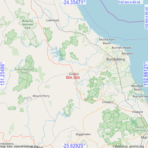
Gin Gin GPS coordinates[2]
24° 59' 37.068" South, 151° 57' 29.088" East
| Map corner | latitude | longitude |
|---|---|---|
| Upper-left | -24.35471°, | 151.25496° |
| Center: | -24.99363°, | 151.95808° |
| Lower-right: | -25.62925°, | 152.66121° |
| Map W x H: | 141.7×141.7 km | = 88×88mi |
| max Lat: | -10.58257° ⇑10.4% North |
| Gin Gin: | -24.99363° |
| min Lat: | ⇓89.6% South -43.31423° |
| min Long | Gin Gin | max Long |
| 113.53327° | 151.95808° | 153.61246° |
| W 82.3%⇐ | ⇒17.7% E |
Elevation
Elevation of Gin Gin is 69 m = 226 ft, and this is 53 m = 174 ft below average elevation for this country.
| Max E: |
1715 m = 5627 ft | 38.3% |
| Avg. | 122 m = 400 ft | |
| Gin Gin | 69 m = 226 ft | |
Min E: |
-2 m = -7 ft | 61.7% |
See also: Australia elevation on elevation.city.
Geographical zone
Gin Gin is located in South temperate zone (between Tropic of Capricorn and the Antarctic Circle). Distance of this Southern Tropic circle is 173.1 km =107.6 mi to North.| Distance of | km | miles | from Gin Gin |
|---|---|---|---|
| Equator | 2779 | 1726.8 | to North |
| Tropic Capricorn | 173.1 | 107.6 | to North |
| Antarctic Circle | 4622.1 | 2872 | to South |
| South Pole | 7228 | 4491.3 | to South |


Nearby cities:
15 places around Gin Gin: (largest is in red/bold)
• Apple Tree Creek
37.2 km =23.1 mi,  131°
131°
• Avoca
37.5 km =23.3 mi,  70°
70°
• Avondale
34.8 km =21.6 mi,  35°
35°
• Branyan
32.9 km =20.4 mi, 74°
• Bucca
20.1 km =12.5 mi,  45°
45°
• Kensington
37.3 km =23.2 mi,  76°
76°
• Millbank
39 km =24.2 mi, 70°
• Moore Park Beach
40.4 km =25.1 mi, 38°
• Mount Perry
37.5 km =23.3 mi,  236°
236°
• North Isis
37 km =23 mi,  123°
123°
• Norville
40.2 km =25 mi, 73°
• Sharon
34.1 km =21.2 mi, 67°
• South Bingera
26.9 km =16.7 mi, 83°
• South Kolan
22.2 km =13.8 mi, 72°
• Svensson Heights
39.5 km =24.5 mi, 72°
Sources, notices
• [Note1] Compared only with cities in Australia existing in our database
• [Src1] Map data: © OpenStreetMap contributors (CC-BY-SA)
• [Src2] Other city data from geonames.org with taken over terms of usage.
• [Src3] Geographical zone / Annual Mean Temperature by Robert A. Rohde @ Wikipedia
