Inverloch geodata
Inverloch (Victoria) is a populated place; located in Australia in Australia/Melbourne (GMT+11) time zone. With population of 5,257 people, there are 1413 cities with bigger population in this country. Compared to other cities in Australia, 96.1% of cities are located further ↑North; 58.4% of cities are located further →East and 72.3% of cities have higher elevation than Inverloch. Note1


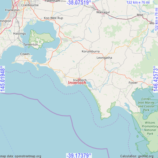
Inverloch GPS coordinates[2]
38° 37' 35.724" South, 145° 43' 21.36" East
| Map corner | latitude | longitude |
|---|---|---|
| Upper-left | -38.07519°, | 145.01948° |
| Center: | -38.62659°, | 145.7226° |
| Lower-right: | -39.17379°, | 146.42573° |
| Map W x H: | 122.2×122.2 km | = 75.9×75.9mi |
| max Lat: | -10.58257° ⇑96.1% North |
| Inverloch: | -38.62659° |
| min Lat: | ⇓3.9% South -43.31423° |
| min Long | Inverloch | max Long |
| 113.53327° | 145.7226° | 153.61246° |
| W 41.6%⇐ | ⇒58.4% E |
Elevation
Elevation of Inverloch is 21 m = 69 ft, and this is 101 m = 331 ft below average elevation for this country.
| Max E: |
1715 m = 5627 ft | 72.3% |
| Avg. | 122 m = 400 ft | |
| Inverloch | 21 m = 69 ft | |
Min E: |
-2 m = -7 ft | 27.7% |
See also: Australia elevation on elevation.city.
Geographical zone
Inverloch is located in South temperate zone (between Tropic of Capricorn and the Antarctic Circle). Distance of this Southern Tropic circle is 1689 km =1049.5 mi to North.| Distance of | km | miles | from Inverloch |
|---|---|---|---|
| Equator | 4294.9 | 2668.7 | to North |
| Tropic Capricorn | 1689 | 1049.5 | to North |
| Antarctic Circle | 3106.3 | 1930.2 | to South |
| South Pole | 5712.2 | 3549.4 | to South |


Nearby cities:
15 places around Inverloch: (largest is in red/bold)
• Cape Paterson
10.1 km =6.3 mi,  240°
240°
• Coronet Bay
31.9 km =19.8 mi,  310°
310°
• Dalyston
16.4 km =10.2 mi,  293°
293°
• Fish Creek
32 km =19.9 mi,  101°
101°
• Grantville
29.6 km =18.4 mi,  325°
325°
• Korumburra
23.4 km =14.5 mi,  22°
22°
• Leongatha
25.7 km =16 mi,  49°
49°
• Loch
28.7 km =17.8 mi,  357°
357°
• Meeniyan
26.4 km =16.4 mi,  77°
77°
• North Wonthaggi
12.5 km =7.8 mi,  295°
295°
• Nyora
32.9 km =20.4 mi,  352°
352°
• Poowong
31.8 km =19.8 mi,  6°
6°
• San Remo
32.1 km =19.9 mi, 290°
• Venus Bay
11.9 km =7.4 mi,  133°
133°
• Wonthaggi
11.4 km =7.1 mi,  281°
281°
Sources, notices
• [Note1] Compared only with cities in Australia existing in our database
• [Src1] Map data: © OpenStreetMap contributors (CC-BY-SA)
• [Src2] Other city data from geonames.org with taken over terms of usage.
• [Src3] Geographical zone / Annual Mean Temperature by Robert A. Rohde @ Wikipedia
