Bullengarook geodata
Bullengarook (Victoria) is a populated place; located in Australia in Australia/Melbourne (GMT+11) time zone. With population of 643 people, there are 4465 cities with bigger population in this country. Compared to other cities in Australia, 82.6% of cities are located further ↑North; 70.3% of cities are located further →East and 93.6% of cities have lower elevation than Bullengarook. Note1


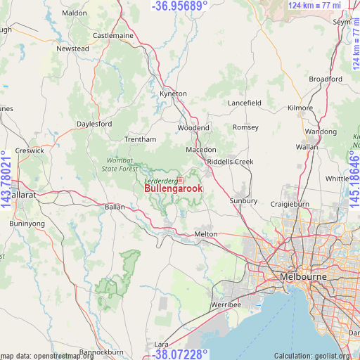
Bullengarook GPS coordinates[2]
37° 31' 0.012" South, 144° 28' 59.988" East
| Map corner | latitude | longitude |
|---|---|---|
| Upper-left | -36.95689°, | 143.78021° |
| Center: | -37.51667°, | 144.48333° |
| Lower-right: | -38.07228°, | 145.18646° |
| Map W x H: | 124×124 km | = 77.1×77.1mi |
| max Lat: | -10.58257° ⇑82.6% North |
| Bullengarook: | -37.51667° |
| min Lat: | ⇓17.4% South -43.31423° |
| min Long | Bullengarook | max Long |
| 113.53327° | 144.48333° | 153.61246° |
| W 29.7%⇐ | ⇒70.3% E |
Elevation
Elevation of Bullengarook is 509 m = 1670 ft, and this is 387 m = 1270 ft above average elevation for this country.
| Max E: |
1715 m = 5627 ft | 6.4% |
| Bullengarook | 509 m 1670 ft | |
| Avg. | 122 m = 400 ft | |
Min E: |
-2 m = -7 ft | 93.6% |
See also: Australia elevation on elevation.city.
Geographical zone
Bullengarook is located in South temperate zone (between Tropic of Capricorn and the Antarctic Circle). Distance of this Southern Tropic circle is 1565.5 km =972.8 mi to North.| Distance of | km | miles | from Bullengarook |
|---|---|---|---|
| Equator | 4171.5 | 2592 | to North |
| Tropic Capricorn | 1565.5 | 972.8 | to North |
| Antarctic Circle | 3229.7 | 2006.8 | to South |
| South Pole | 5835.6 | 3626.1 | to South |


Nearby cities:
15 places around Bullengarook: (largest is in red/bold)
• Bacchus Marsh
17.8 km =11.1 mi,  192°
192°
• Darley
16.1 km =10 mi, 192°
• Gisborne
10.3 km =6.4 mi,  72°
72°
• Gisborne South
11.1 km =6.9 mi,  104°
104°
• Greendale
17.1 km =10.6 mi,  253°
253°
• Hopetoun Park
19.6 km =12.2 mi,  175°
175°
• Kurunjang
20.3 km =12.6 mi,  150°
150°
• Macedon
12.9 km =8 mi,  32°
32°
• Maddingley
19.3 km =12 mi, 193°
• Melton West
19.5 km =12.1 mi,  157°
157°
• Mount Macedon
15.7 km =9.8 mi, 34°
• New Gisborne
12 km =7.5 mi,  58°
58°
• Toolern Vale
13.8 km =8.6 mi,  132°
132°
• Trentham
20.1 km =12.5 mi,  314°
314°
• Woodend
18.5 km =11.5 mi,  12°
12°
Sources, notices
• [Note1] Compared only with cities in Australia existing in our database
• [Src1] Map data: © OpenStreetMap contributors (CC-BY-SA)
• [Src2] Other city data from geonames.org with taken over terms of usage.
• [Src3] Geographical zone / Annual Mean Temperature by Robert A. Rohde @ Wikipedia
