Ballan geodata
Ballan (Victoria) is a populated place; located in Australia in Australia/Melbourne (GMT+11) time zone. With population of 2,919 people, there are 2304 cities with bigger population in this country. Compared to other cities in Australia, 83.4% of cities are located further ↑North; 71.9% of cities are located further →East and 93.5% of cities have lower elevation than Ballan. Note1


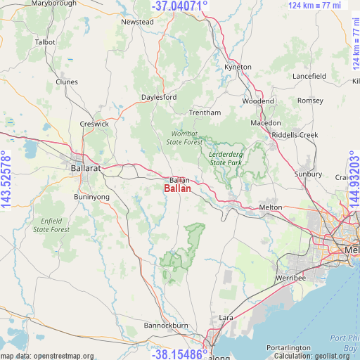
Ballan GPS coordinates[2]
37° 35' 59.532" South, 144° 13' 44.04" East
| Map corner | latitude | longitude |
|---|---|---|
| Upper-left | -37.04071°, | 143.52578° |
| Center: | -37.59987°, | 144.2289° |
| Lower-right: | -38.15486°, | 144.93203° |
| Map W x H: | 123.9×123.9 km | = 77×77mi |
| max Lat: | -10.58257° ⇑83.4% North |
| Ballan: | -37.59987° |
| min Lat: | ⇓16.6% South -43.31423° |
| min Long | Ballan | max Long |
| 113.53327° | 144.2289° | 153.61246° |
| W 28.1%⇐ | ⇒71.9% E |
Elevation
Elevation of Ballan is 506 m = 1660 ft, and this is 384 m = 1260 ft above average elevation for this country.
| Max E: |
1715 m = 5627 ft | 6.5% |
| Ballan | 506 m 1660 ft | |
| Avg. | 122 m = 400 ft | |
Min E: |
-2 m = -7 ft | 93.5% |
See also: Australia elevation on elevation.city.
Geographical zone
Ballan is located in South temperate zone (between Tropic of Capricorn and the Antarctic Circle). Distance of this Southern Tropic circle is 1574.8 km =978.5 mi to North.| Distance of | km | miles | from Ballan |
|---|---|---|---|
| Equator | 4180.7 | 2597.8 | to North |
| Tropic Capricorn | 1574.8 | 978.5 | to North |
| Antarctic Circle | 3220.5 | 2001.1 | to South |
| South Pole | 5826.3 | 3620.3 | to South |


Nearby cities:
15 places around Ballan: (largest is in red/bold)
• Bacchus Marsh
20.1 km =12.5 mi,  113°
113°
• Brown Hill
28.2 km =17.5 mi,  282°
282°
• Bullengarook
24.3 km =15.1 mi,  67°
67°
• Darley
20 km =12.4 mi, 108°
• Daylesford
29.8 km =18.5 mi,  345°
345°
• Eureka
30.8 km =19.1 mi, 277°
• Gordon
10.7 km =6.6 mi, 280°
• Greendale
7.4 km =4.6 mi,  53°
53°
• Hopetoun Park
26.1 km =16.2 mi, 113°
• Maddingley
20.3 km =12.6 mi,  117°
117°
• Meredith
30.4 km =18.9 mi,  206°
206°
• Mount Clear
30.4 km =18.9 mi,  269°
269°
• Mount Egerton
11.9 km =7.4 mi,  251°
251°
• Trentham
24.9 km =15.5 mi,  19°
19°
• Warrenheip
26.3 km =16.3 mi, 278°
Sources, notices
• [Note1] Compared only with cities in Australia existing in our database
• [Src1] Map data: © OpenStreetMap contributors (CC-BY-SA)
• [Src2] Other city data from geonames.org with taken over terms of usage.
• [Src3] Geographical zone / Annual Mean Temperature by Robert A. Rohde @ Wikipedia
