Greendale geodata
Greendale (Victoria) is a populated place; located in Australia in Australia/Melbourne (GMT+11) time zone. With population of 588 people, there are 4603 cities with bigger population in this country. Compared to other cities in Australia, 83% of cities are located further ↑North; 71.4% of cities are located further →East and 91.7% of cities have lower elevation than Greendale. Note1


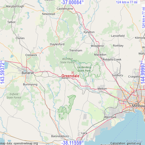
Greendale GPS coordinates[2]
37° 33' 37.08" South, 144° 17' 48.624" East
| Map corner | latitude | longitude |
|---|---|---|
| Upper-left | -37.00084°, | 143.59372° |
| Center: | -37.5603°, | 144.29684° |
| Lower-right: | -38.11559°, | 144.99997° |
| Map W x H: | 123.9×123.9 km | = 77×77mi |
| max Lat: | -10.58257° ⇑83% North |
| Greendale: | -37.5603° |
| min Lat: | ⇓17% South -43.31423° |
| min Long | Greendale | max Long |
| 113.53327° | 144.29684° | 153.61246° |
| W 28.6%⇐ | ⇒71.4% E |
Elevation
Elevation of Greendale is 433 m = 1421 ft, and this is 311 m = 1020 ft above average elevation for this country.
| Max E: |
1715 m = 5627 ft | 8.3% |
| Greendale | 433 m 1421 ft | |
| Avg. | 122 m = 400 ft | |
Min E: |
-2 m = -7 ft | 91.7% |
See also: Australia elevation on elevation.city.
Geographical zone
Greendale is located in South temperate zone (between Tropic of Capricorn and the Antarctic Circle). Distance of this Southern Tropic circle is 1570.4 km =975.8 mi to North.| Distance of | km | miles | from Greendale |
|---|---|---|---|
| Equator | 4176.3 | 2595 | to North |
| Tropic Capricorn | 1570.4 | 975.8 | to North |
| Antarctic Circle | 3224.9 | 2003.9 | to South |
| South Pole | 5830.7 | 3623 | to South |


Nearby cities:
15 places around Greendale: (largest is in red/bold)
• Bacchus Marsh
17.6 km =10.9 mi,  135°
135°
• Ballan
7.4 km =4.6 mi,  233°
233°
• Bullengarook
17.1 km =10.6 mi,  73°
73°
• Darley
16.9 km =10.5 mi,  130°
130°
• Daylesford
27.9 km =17.3 mi,  330°
330°
• Gisborne
27.4 km =17 mi, 73°
• Gisborne South
27.2 km =16.9 mi,  85°
85°
• Gordon
16.7 km =10.4 mi,  261°
261°
• Hopetoun Park
23.2 km =14.4 mi, 129°
• Maddingley
18.3 km =11.4 mi, 139°
• Melton West
27.3 km =17 mi,  118°
118°
• Mount Egerton
19.1 km =11.9 mi,  244°
244°
• Toolern Vale
27.1 km =16.8 mi,  99°
99°
• Trentham
19.2 km =11.9 mi,  6°
6°
• Tylden
27.8 km =17.3 mi,  20°
20°
Sources, notices
• [Note1] Compared only with cities in Australia existing in our database
• [Src1] Map data: © OpenStreetMap contributors (CC-BY-SA)
• [Src2] Other city data from geonames.org with taken over terms of usage.
• [Src3] Geographical zone / Annual Mean Temperature by Robert A. Rohde @ Wikipedia
