Bilpin geodata
Bilpin (New South Wales) is a populated place; located in Australia in Australia/Sydney (GMT+11) time zone. With population of 653 people, there are 4428 cities with bigger population in this country. Compared to other cities in Australia, 53.4% of cities are located further ↓South; 59% of cities are located further ←West and 95.7% of cities have lower elevation than Bilpin. Note1


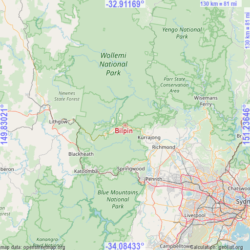
Bilpin GPS coordinates[2]
33° 30' 0" South, 150° 31' 59.988" East
| Map corner | latitude | longitude |
|---|---|---|
| Upper-left | -32.91169°, | 149.83021° |
| Center: | -33.5°, | 150.53333° |
| Lower-right: | -34.08433°, | 151.23646° |
| Map W x H: | 130.4×130.4 km | = 81×81mi |
| max Lat: | -10.58257° ⇑46.6% North |
| Bilpin: | -33.5° |
| min Lat: | ⇓53.4% South -43.31423° |
| min Long | Bilpin | max Long |
| 113.53327° | 150.53333° | 153.61246° |
| W 59%⇐ | ⇒41% E |
Elevation
Elevation of Bilpin is 597 m = 1959 ft, and this is 475 m = 1558 ft above average elevation for this country.
| Max E: |
1715 m = 5627 ft | 4.3% |
| Bilpin | 597 m 1959 ft | |
| Avg. | 122 m = 400 ft | |
Min E: |
-2 m = -7 ft | 95.7% |
See also: Australia elevation on elevation.city.
Geographical zone
Bilpin is located in South temperate zone (between Tropic of Capricorn and the Antarctic Circle). Distance of this Southern Tropic circle is 1118.9 km =695.3 mi to North.| Distance of | km | miles | from Bilpin |
|---|---|---|---|
| Equator | 3724.9 | 2314.5 | to North |
| Tropic Capricorn | 1118.9 | 695.3 | to North |
| Antarctic Circle | 3676.3 | 2284.3 | to South |
| South Pole | 6282.2 | 3903.6 | to South |


Nearby cities:
15 places around Bilpin: (largest is in red/bold)
• Agnes Banks
20.9 km =13 mi,  125°
125°
• Bowen Mountain
11.7 km =7.3 mi, 133°
• Faulconbridge
22.2 km =13.8 mi,  180°
180°
• Glossodia
22.7 km =14.1 mi,  100°
100°
• Grose Vale
16 km =9.9 mi, 125°
• Grose Wold
17.8 km =11.1 mi, 127°
• Hobartville
22.6 km =14 mi,  120°
120°
• Kurmond
16.1 km =10 mi,  111°
111°
• Kurrajong Heights
9.4 km =5.8 mi, 109°
• Kurrajong Hills
11.6 km =7.2 mi, 108°
• North Richmond
19.5 km =12.1 mi, 117°
• Springwood
22.3 km =13.9 mi, 176°
• Valley Heights
22.7 km =14.1 mi,  168°
168°
• Winmalee
21.1 km =13.1 mi,  159°
159°
• Yarramundi
18.7 km =11.6 mi,  135°
135°
Sources, notices
• [Note1] Compared only with cities in Australia existing in our database
• [Src1] Map data: © OpenStreetMap contributors (CC-BY-SA)
• [Src2] Other city data from geonames.org with taken over terms of usage.
• [Src3] Geographical zone / Annual Mean Temperature by Robert A. Rohde @ Wikipedia
