Beaufort geodata
Beaufort (Victoria) is a populated place; located in Australia in Australia/Melbourne (GMT+11) time zone. With population of 1,539 people, there are 3252 cities with bigger population in this country. Compared to other cities in Australia, 82.4% of cities are located further ↑North; 73.7% of cities are located further →East and 90.5% of cities have lower elevation than Beaufort. Note1


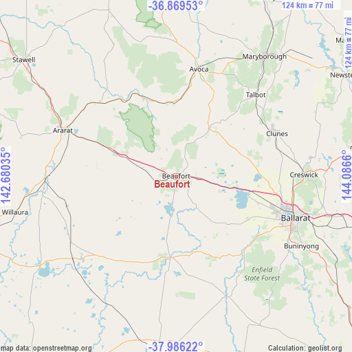
Beaufort GPS coordinates[2]
37° 25' 47.856" South, 143° 23' 0.492" East
| Map corner | latitude | longitude |
|---|---|---|
| Upper-left | -36.86953°, | 142.68035° |
| Center: | -37.42996°, | 143.38347° |
| Lower-right: | -37.98622°, | 144.0866° |
| Map W x H: | 124.2×124.2 km | = 77.2×77.2mi |
| max Lat: | -10.58257° ⇑82.4% North |
| Beaufort: | -37.42996° |
| min Lat: | ⇓17.6% South -43.31423° |
| min Long | Beaufort | max Long |
| 113.53327° | 143.38347° | 153.61246° |
| W 26.3%⇐ | ⇒73.7% E |
Elevation
Elevation of Beaufort is 391 m = 1283 ft, and this is 269 m = 883 ft above average elevation for this country.
| Max E: |
1715 m = 5627 ft | 9.5% |
| Beaufort | 391 m 1283 ft | |
| Avg. | 122 m = 400 ft | |
Min E: |
-2 m = -7 ft | 90.5% |
See also: Australia elevation on elevation.city.
Geographical zone
Beaufort is located in South temperate zone (between Tropic of Capricorn and the Antarctic Circle). Distance of this Southern Tropic circle is 1555.9 km =966.8 mi to North.| Distance of | km | miles | from Beaufort |
|---|---|---|---|
| Equator | 4161.8 | 2586 | to North |
| Tropic Capricorn | 1555.9 | 966.8 | to North |
| Antarctic Circle | 3239.4 | 2012.9 | to South |
| South Pole | 5845.2 | 3632 | to South |


Nearby cities:
15 places around Beaufort: (largest is in red/bold)
• Avoca
38.6 km =24 mi,  11°
11°
• Cardigan
34.3 km =21.3 mi,  109°
109°
• Cardigan Village
30.7 km =19.1 mi, 108°
• Clunes
38.7 km =24 mi,  67°
67°
• Haddon
34.9 km =21.7 mi,  122°
122°
• Lake Gardens
40.3 km =25 mi, 108°
• Linton
32.6 km =20.3 mi,  150°
150°
• Lucas
36.9 km =22.9 mi, 110°
• Miners Rest
37.3 km =23.2 mi,  98°
98°
• Mitchell Park
36 km =22.4 mi, 103°
• Scarsdale
37.3 km =23.2 mi,  137°
137°
• Skipton
28.5 km =17.7 mi,  183°
183°
• Smythes Creek
40 km =24.9 mi, 118°
• Smythesdale
35.7 km =22.2 mi,  131°
131°
• Snake Valley
26.9 km =16.7 mi, 138°
Sources, notices
• [Note1] Compared only with cities in Australia existing in our database
• [Src1] Map data: © OpenStreetMap contributors (CC-BY-SA)
• [Src2] Other city data from geonames.org with taken over terms of usage.
• [Src3] Geographical zone / Annual Mean Temperature by Robert A. Rohde @ Wikipedia
