Hope Vale geodata
Hope Vale (Queensland) is a populated place; located in Australia in Australia/Brisbane (GMT+10) time zone. With population of 1,049 people, there are 3755 cities with bigger population in this country. Compared to other cities in Australia, 98% of cities are located further ↓South; 64.2% of cities are located further →East and 56.3% of cities have lower elevation than Hope Vale. Note1


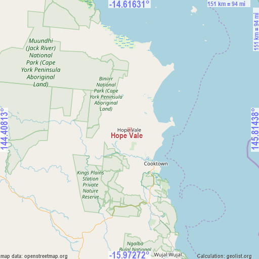
Hope Vale GPS coordinates[2]
15° 17' 44.196" South, 145° 6' 40.5" East
| Map corner | latitude | longitude |
|---|---|---|
| Upper-left | -14.61631°, | 144.40813° |
| Center: | -15.29561°, | 145.11125° |
| Lower-right: | -15.97272°, | 145.81438° |
| Map W x H: | 150.8×150.8 km | = 93.7×93.7mi |
| max Lat: | -10.58257° ⇑2% North |
| Hope Vale: | -15.29561° |
| min Lat: | ⇓98% South -43.31423° |
| min Long | Hope Vale | max Long |
| 113.53327° | 145.11125° | 153.61246° |
| W 35.8%⇐ | ⇒64.2% E |
Elevation
Elevation of Hope Vale is 56 m = 184 ft, and this is 66 m = 217 ft below average elevation for this country.
| Max E: |
1715 m = 5627 ft | 43.7% |
| Avg. | 122 m = 400 ft | |
| Hope Vale | 56 m = 184 ft | |
Min E: |
-2 m = -7 ft | 56.3% |
See also: Australia elevation on elevation.city.
Geographical zone
Hope Vale is located in South Torrid zone (between Equator and Tropic of Capricorn). Distance of this Southern Tropic circle is 905.2 km =562.5 mi to South.| Distance of | km | miles | from Hope Vale |
|---|---|---|---|
| Equator | 1700.7 | 1056.8 | to North |
| Tropic Capricorn | 905.2 | 562.5 | to South |
| Antarctic Circle | 5700.5 | 3542.1 | to South |
| South Pole | 8306.3 | 5161.3 | to South |


Nearby cities:
15 places around Hope Vale: (largest is in red/bold)
• Biboohra
177.8 km =110.5 mi,  168°
168°
• Clifton Beach
173.8 km =108 mi,  159°
159°
• Cooktown
24.1 km =15 mi,  141°
141°
• Cooya Beach
132 km =82 mi, 166°
• Craiglie
143.3 km =89 mi, 164°
• Julatten
147.9 km =91.9 mi, 170°
• Kewarra Beach
176.3 km =109.5 mi, 159°
• Kuranda
178.6 km =111 mi, 161°
• Laura
101 km =62.8 mi,  255°
255°
• Mossman
132.7 km =82.5 mi, 167°
• Mowbray
146 km =90.7 mi, 164°
• Palm Cove
172.3 km =107.1 mi, 159°
• Port Douglas
137.5 km =85.4 mi, 163°
• Trinity Beach
177.4 km =110.2 mi, 159°
• Trinity Park
179.6 km =111.6 mi, 159°
Sources, notices
• [Note1] Compared only with cities in Australia existing in our database
• [Src1] Map data: © OpenStreetMap contributors (CC-BY-SA)
• [Src2] Other city data from geonames.org with taken over terms of usage.
• [Src3] Geographical zone / Annual Mean Temperature by Robert A. Rohde @ Wikipedia
