Cooktown geodata
Cooktown (Queensland) is a populated place; located in Australia in Australia/Brisbane (GMT+10) time zone. With population of 3,173 people, there are 2147 cities with bigger population in this country. Compared to other cities in Australia, 98% of cities are located further ↓South; 62% of cities are located further →East and 99.9% of cities have higher elevation than Cooktown. Note1


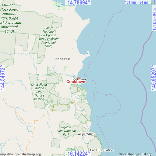
Cooktown GPS coordinates[2]
15° 27' 56.52" South, 145° 14' 59.424" East
| Map corner | latitude | longitude |
|---|---|---|
| Upper-left | -14.78694°, | 144.54672° |
| Center: | -15.4657°, | 145.24984° |
| Lower-right: | -16.14224°, | 145.95297° |
| Map W x H: | 150.7×150.7 km | = 93.6×93.6mi |
| max Lat: | -10.58257° ⇑2% North |
| Cooktown: | -15.4657° |
| min Lat: | ⇓98% South -43.31423° |
| min Long | Cooktown | max Long |
| 113.53327° | 145.24984° | 153.61246° |
| W 38%⇐ | ⇒62% E |
Elevation
Elevation of Cooktown is 1 m = 3 ft, and this is 121 m = 397 ft below average elevation for this country.
| Max E: |
1715 m = 5627 ft | 99.9% |
| Avg. | 122 m = 400 ft | |
| Cooktown | 1 m = 3 ft | |
Min E: |
-2 m = -7 ft | 0.1% |
See also: Australia elevation on elevation.city.
Geographical zone
Cooktown is located in South Torrid zone (between Equator and Tropic of Capricorn). Distance of this Southern Tropic circle is 886.3 km =550.7 mi to South.| Distance of | km | miles | from Cooktown |
|---|---|---|---|
| Equator | 1719.6 | 1068.5 | to North |
| Tropic Capricorn | 886.3 | 550.7 | to South |
| Antarctic Circle | 5681.5 | 3530.3 | to South |
| South Pole | 8287.4 | 5149.6 | to South |


Nearby cities:
15 places around Cooktown: (largest is in red/bold)
• Biboohra
156.8 km =97.4 mi,  172°
172°
• Clifton Beach
151.1 km =93.9 mi,  162°
162°
• Cooya Beach
110.5 km =68.7 mi, 171°
• Craiglie
121.5 km =75.5 mi, 168°
• Hope Vale
24.1 km =15 mi,  321°
321°
• Julatten
127.3 km =79.1 mi,  175°
175°
• Kewarra Beach
153.6 km =95.4 mi, 162°
• Kuranda
156.2 km =97.1 mi, 164°
• Laura
112.8 km =70.1 mi,  266°
266°
• Mossman
111.6 km =69.3 mi, 173°
• Mowbray
124.1 km =77.1 mi, 168°
• Palm Cove
149.6 km =93 mi, 162°
• Port Douglas
115.6 km =71.8 mi, 168°
• Trinity Beach
154.7 km =96.1 mi, 162°
• Yorkeys Knob
156.9 km =97.5 mi, 161°
Sources, notices
• [Note1] Compared only with cities in Australia existing in our database
• [Src1] Map data: © OpenStreetMap contributors (CC-BY-SA)
• [Src2] Other city data from geonames.org with taken over terms of usage.
• [Src3] Geographical zone / Annual Mean Temperature by Robert A. Rohde @ Wikipedia
