Craigie geodata
Craigie (Western Australia) is a section of populated place; located in Australia in Australia/Perth (GMT+8) time zone. With population of 5,713 people, there are 1284 cities with bigger population in this country. Compared to other cities in Australia, 68.3% of cities are located further ↓South; 96.9% of cities are located further →East and 53.7% of cities have higher elevation than Craigie. Note1


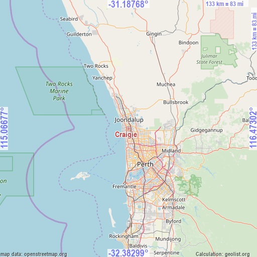
Craigie GPS coordinates[2]
31° 47' 14.172" South, 115° 46' 11.604" East
| Map corner | latitude | longitude |
|---|---|---|
| Upper-left | -31.18768°, | 115.06677° |
| Center: | -31.78727°, | 115.76989° |
| Lower-right: | -32.38299°, | 116.47302° |
| Map W x H: | 132.9×132.9 km | = 82.6×82.6mi |
| max Lat: | -10.58257° ⇑31.7% North |
| Craigie: | -31.78727° |
| min Lat: | ⇓68.3% South -43.31423° |
| min Long | Craigie | max Long |
| 113.53327° | 115.76989° | 153.61246° |
| W 3.1%⇐ | ⇒96.9% E |
Elevation
Elevation of Craigie is 40 m = 131 ft, and this is 82 m = 269 ft below average elevation for this country.
| Max E: |
1715 m = 5627 ft | 53.7% |
| Avg. | 122 m = 400 ft | |
| Craigie | 40 m = 131 ft | |
Min E: |
-2 m = -7 ft | 46.3% |
See also: Australia elevation on elevation.city.
Geographical zone
Craigie is located in South temperate zone (between Tropic of Capricorn and the Antarctic Circle). Distance of this Southern Tropic circle is 928.5 km =576.9 mi to North.| Distance of | km | miles | from Craigie |
|---|---|---|---|
| Equator | 3534.4 | 2196.2 | to North |
| Tropic Capricorn | 928.5 | 576.9 | to North |
| Antarctic Circle | 3866.8 | 2402.7 | to South |
| South Pole | 6472.6 | 4021.9 | to South |


Nearby cities:
15 places around Craigie: (largest is in red/bold)
• Beldon
1.6 km =1 mi,  334°
334°
• Connolly
4.7 km =2.9 mi,  336°
336°
• Edgewater
2.7 km =1.7 mi,  25°
25°
• Heathridge
2.9 km =1.8 mi, 339°
• Hillarys
3.5 km =2.2 mi,  231°
231°
• Joondalup
4.8 km =3 mi,  358°
358°
• Kallaroo
1.7 km =1.1 mi,  255°
255°
• Kingsley
3.9 km =2.4 mi,  131°
131°
• Mullaloo
3.3 km =2.1 mi,  286°
286°
• Ocean Reef
4.5 km =2.8 mi,  314°
314°
• Padbury
2.1 km =1.3 mi,  182°
182°
• Pearsall
4.6 km =2.9 mi,  81°
81°
• Sorrento
4.5 km =2.8 mi,  201°
201°
• Wanneroo
5 km =3.1 mi, 34°
• Woodvale
2.5 km =1.6 mi,  95°
95°
Sources, notices
• [Note1] Compared only with cities in Australia existing in our database
• [Src1] Map data: © OpenStreetMap contributors (CC-BY-SA)
• [Src2] Other city data from geonames.org with taken over terms of usage.
• [Src3] Geographical zone / Annual Mean Temperature by Robert A. Rohde @ Wikipedia
