Coleambally geodata
Coleambally (New South Wales) is a populated place; located in Australia in Australia/Sydney (GMT+11) time zone. With population of 1,276 people, there are 3497 cities with bigger population in this country. Compared to other cities in Australia, 65.8% of cities are located further ↑North; 57.6% of cities are located further →East and 74.3% of cities have lower elevation than Coleambally. Note1


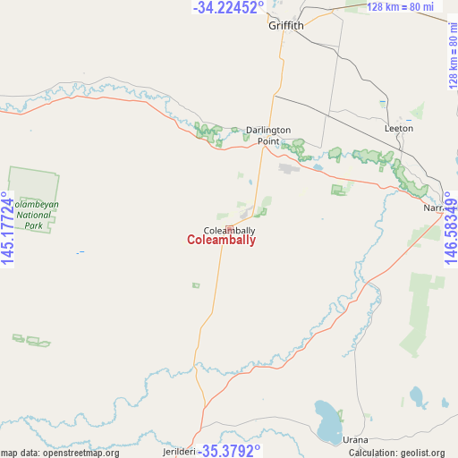
Coleambally GPS coordinates[2]
34° 48' 13.968" South, 145° 52' 49.296" East
| Map corner | latitude | longitude |
|---|---|---|
| Upper-left | -34.22452°, | 145.17724° |
| Center: | -34.80388°, | 145.88036° |
| Lower-right: | -35.3792°, | 146.58349° |
| Map W x H: | 128.4×128.4 km | = 79.8×79.8mi |
| max Lat: | -10.58257° ⇑65.8% North |
| Coleambally: | -34.80388° |
| min Lat: | ⇓34.2% South -43.31423° |
| min Long | Coleambally | max Long |
| 113.53327° | 145.88036° | 153.61246° |
| W 42.4%⇐ | ⇒57.6% E |
Elevation
Elevation of Coleambally is 125 m = 410 ft, and this is 3 m = 10 ft above average elevation for this country.
| Max E: |
1715 m = 5627 ft | 25.7% |
| Coleambally | 125 m 410 ft | |
| Avg. | 122 m = 400 ft | |
Min E: |
-2 m = -7 ft | 74.3% |
See also: Australia elevation on elevation.city.
Geographical zone
Coleambally is located in South temperate zone (between Tropic of Capricorn and the Antarctic Circle). Distance of this Southern Tropic circle is 1263.9 km =785.4 mi to North.| Distance of | km | miles | from Coleambally |
|---|---|---|---|
| Equator | 3869.8 | 2404.6 | to North |
| Tropic Capricorn | 1263.9 | 785.4 | to North |
| Antarctic Circle | 3531.3 | 2194.2 | to South |
| South Pole | 6137.2 | 3813.5 | to South |


Nearby cities:
15 places around Coleambally: (largest is in red/bold)
• Barellan
85.7 km =53.3 mi,  47°
47°
• Berrigan
95.3 km =59.2 mi,  183°
183°
• Bilbul
63.8 km =39.6 mi,  21°
21°
• Darlington Point
28.2 km =17.5 mi, 22°
• Griffith
59.4 km =36.9 mi, 15°
• Hanwood
54.6 km =33.9 mi, 15°
• Jerilderie
63.1 km =39.2 mi,  192°
192°
• Lake Wyangan
64.9 km =40.3 mi,  11°
11°
• Leeton
55.6 km =34.5 mi,  59°
59°
• Lockhart
89.4 km =55.6 mi,  121°
121°
• Narrandera
61.6 km =38.3 mi,  84°
84°
• Tharbogang
60.7 km =37.7 mi, 9°
• Yanco
53.5 km =33.2 mi, 64°
• Yenda
68.8 km =42.8 mi,  25°
25°
• Yoogali
59.1 km =36.7 mi, 18°
Sources, notices
• [Note1] Compared only with cities in Australia existing in our database
• [Src1] Map data: © OpenStreetMap contributors (CC-BY-SA)
• [Src2] Other city data from geonames.org with taken over terms of usage.
• [Src3] Geographical zone / Annual Mean Temperature by Robert A. Rohde @ Wikipedia
