Griffith geodata
Griffith (New South Wales) is a populated place; located in Australia in Australia/Sydney (GMT+11) time zone. With population of 18,154 people, there are 193 cities with bigger population in this country. Compared to other cities in Australia, 61.7% of cities are located further ↑North; 56.8% of cities are located further →East and 74.7% of cities have lower elevation than Griffith. Note1


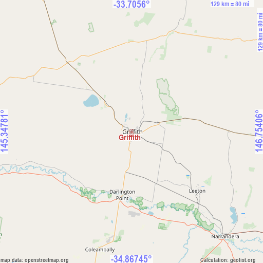
Griffith GPS coordinates[2]
34° 17' 18.708" South, 146° 3' 3.348" East
| Map corner | latitude | longitude |
|---|---|---|
| Upper-left | -33.7056°, | 145.34781° |
| Center: | -34.28853°, | 146.05093° |
| Lower-right: | -34.86745°, | 146.75406° |
| Map W x H: | 129.2×129.2 km | = 80.3×80.3mi |
| max Lat: | -10.58257° ⇑61.7% North |
| Griffith: | -34.28853° |
| min Lat: | ⇓38.3% South -43.31423° |
| min Long | Griffith | max Long |
| 113.53327° | 146.05093° | 153.61246° |
| W 43.2%⇐ | ⇒56.8% E |
Elevation
Elevation of Griffith is 128 m = 420 ft, and this is 6 m = 20 ft above average elevation for this country.
| Max E: |
1715 m = 5627 ft | 25.3% |
| Griffith | 128 m 420 ft | |
| Avg. | 122 m = 400 ft | |
Min E: |
-2 m = -7 ft | 74.7% |
See also: Australia elevation on elevation.city.
Geographical zone
Griffith is located in South temperate zone (between Tropic of Capricorn and the Antarctic Circle). Distance of this Southern Tropic circle is 1206.6 km =749.7 mi to North.| Distance of | km | miles | from Griffith |
|---|---|---|---|
| Equator | 3812.5 | 2369 | to North |
| Tropic Capricorn | 1206.6 | 749.7 | to North |
| Antarctic Circle | 3588.6 | 2229.9 | to South |
| South Pole | 6194.5 | 3849.1 | to South |


Nearby cities:
15 places around Griffith: (largest is in red/bold)
• Ardlethan
78.5 km =48.8 mi,  95°
95°
• Barellan
47.9 km =29.8 mi,  89°
89°
• Bilbul
8.4 km =5.2 mi,  77°
77°
• Coleambally
59.4 km =36.9 mi,  195°
195°
• Darlington Point
31.6 km =19.6 mi,  188°
188°
• Ganmain
106.5 km =66.2 mi,  121°
121°
• Hanwood
4.8 km =3 mi, 190°
• Hillston
101.5 km =63.1 mi,  332°
332°
• Lake Wyangan
6.9 km =4.3 mi,  336°
336°
• Leeton
43.7 km =27.2 mi,  131°
131°
• Narrandera
68.6 km =42.6 mi,  138°
138°
• Tharbogang
5.9 km =3.7 mi,  295°
295°
• Yanco
47.6 km =29.6 mi, 136°
• Yenda
14.8 km =9.2 mi,  70°
70°
• Yoogali
3.3 km =2.1 mi,  111°
111°
Sources, notices
• [Note1] Compared only with cities in Australia existing in our database
• [Src1] Map data: © OpenStreetMap contributors (CC-BY-SA)
• [Src2] Other city data from geonames.org with taken over terms of usage.
• [Src3] Geographical zone / Annual Mean Temperature by Robert A. Rohde @ Wikipedia
