Leeton geodata
Leeton (New South Wales) is a populated place; located in Australia in Australia/Sydney (GMT+11) time zone. With population of 8,634 people, there are 743 cities with bigger population in this country. Compared to other cities in Australia, 63.6% of cities are located further ↑North; 55.6% of cities are located further →East and 77% of cities have lower elevation than Leeton. Note1


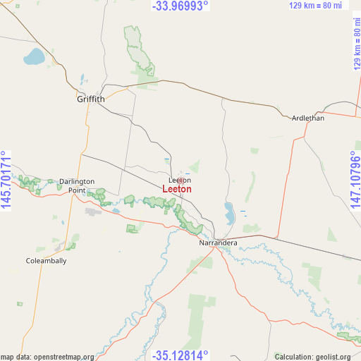
Leeton GPS coordinates[2]
34° 33' 3.78" South, 146° 24' 17.388" East
| Map corner | latitude | longitude |
|---|---|---|
| Upper-left | -33.96993°, | 145.70171° |
| Center: | -34.55105°, | 146.40483° |
| Lower-right: | -35.12814°, | 147.10796° |
| Map W x H: | 128.8×128.8 km | = 80×80mi |
| max Lat: | -10.58257° ⇑63.6% North |
| Leeton: | -34.55105° |
| min Lat: | ⇓36.4% South -43.31423° |
| min Long | Leeton | max Long |
| 113.53327° | 146.40483° | 153.61246° |
| W 44.4%⇐ | ⇒55.6% E |
Elevation
Elevation of Leeton is 148 m = 486 ft, and this is 26 m = 85 ft above average elevation for this country.
| Max E: |
1715 m = 5627 ft | 23% |
| Leeton | 148 m 486 ft | |
| Avg. | 122 m = 400 ft | |
Min E: |
-2 m = -7 ft | 77% |
See also: Australia elevation on elevation.city.
Geographical zone
Leeton is located in South temperate zone (between Tropic of Capricorn and the Antarctic Circle). Distance of this Southern Tropic circle is 1235.8 km =767.9 mi to North.| Distance of | km | miles | from Leeton |
|---|---|---|---|
| Equator | 3841.7 | 2387.1 | to North |
| Tropic Capricorn | 1235.8 | 767.9 | to North |
| Antarctic Circle | 3559.5 | 2211.8 | to South |
| South Pole | 6165.3 | 3830.9 | to South |


Nearby cities:
15 places around Leeton: (largest is in red/bold)
• Ardlethan
50.4 km =31.3 mi,  64°
64°
• Barellan
33.3 km =20.7 mi,  27°
27°
• Bilbul
39.4 km =24.5 mi,  322°
322°
• Coleambally
55.6 km =34.5 mi,  239°
239°
• Coolamon
78.1 km =48.5 mi,  112°
112°
• Darlington Point
37.2 km =23.1 mi,  266°
266°
• Ganmain
63.9 km =39.7 mi, 114°
• Griffith
43.7 km =27.2 mi,  311°
311°
• Hanwood
41.3 km =25.7 mi, 306°
• Lake Wyangan
50 km =31.1 mi, 315°
• Narrandera
25.6 km =15.9 mi,  148°
148°
• Tharbogang
49.3 km =30.6 mi, 310°
• Yanco
5.3 km =3.3 mi,  175°
175°
• Yenda
38.7 km =24 mi,  331°
331°
• Yoogali
40.6 km =25.2 mi, 313°
Sources, notices
• [Note1] Compared only with cities in Australia existing in our database
• [Src1] Map data: © OpenStreetMap contributors (CC-BY-SA)
• [Src2] Other city data from geonames.org with taken over terms of usage.
• [Src3] Geographical zone / Annual Mean Temperature by Robert A. Rohde @ Wikipedia
