Yoogali geodata
Yoogali (New South Wales) is a populated place; located in Australia in Australia/Sydney (GMT+11) time zone. With population of 1,236 people, there are 3534 cities with bigger population in this country. Compared to other cities in Australia, 61.8% of cities are located further ↑North; 56.7% of cities are located further →East and 74.6% of cities have lower elevation than Yoogali. Note1


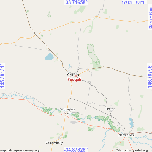
Yoogali GPS coordinates[2]
34° 17' 57.984" South, 146° 5' 3.948" East
| Map corner | latitude | longitude |
|---|---|---|
| Upper-left | -33.71658°, | 145.38131° |
| Center: | -34.29944°, | 146.08443° |
| Lower-right: | -34.87828°, | 146.78756° |
| Map W x H: | 129.2×129.2 km | = 80.3×80.3mi |
| max Lat: | -10.58257° ⇑61.8% North |
| Yoogali: | -34.29944° |
| min Lat: | ⇓38.2% South -43.31423° |
| min Long | Yoogali | max Long |
| 113.53327° | 146.08443° | 153.61246° |
| W 43.3%⇐ | ⇒56.7% E |
Elevation
Elevation of Yoogali is 127 m = 417 ft, and this is 5 m = 16 ft above average elevation for this country.
| Max E: |
1715 m = 5627 ft | 25.4% |
| Yoogali | 127 m 417 ft | |
| Avg. | 122 m = 400 ft | |
Min E: |
-2 m = -7 ft | 74.6% |
See also: Australia elevation on elevation.city.
Geographical zone
Yoogali is located in South temperate zone (between Tropic of Capricorn and the Antarctic Circle). Distance of this Southern Tropic circle is 1207.8 km =750.5 mi to North.| Distance of | km | miles | from Yoogali |
|---|---|---|---|
| Equator | 3813.7 | 2369.7 | to North |
| Tropic Capricorn | 1207.8 | 750.5 | to North |
| Antarctic Circle | 3587.4 | 2229.1 | to South |
| South Pole | 6193.3 | 3848.3 | to South |


Nearby cities:
15 places around Yoogali: (largest is in red/bold)
• Ardlethan
75.3 km =46.8 mi,  94°
94°
• Barellan
44.8 km =27.8 mi, 87°
• Bilbul
6 km =3.7 mi,  59°
59°
• Coleambally
59.1 km =36.7 mi,  198°
198°
• Darlington Point
31 km =19.3 mi,  194°
194°
• Ganmain
103.2 km =64.1 mi,  122°
122°
• Griffith
3.3 km =2.1 mi,  291°
291°
• Hanwood
5.3 km =3.3 mi,  228°
228°
• Hillston
104 km =64.6 mi,  330°
330°
• Lake Wyangan
9.5 km =5.9 mi,  322°
322°
• Leeton
40.6 km =25.2 mi,  133°
133°
• Narrandera
65.6 km =40.8 mi,  139°
139°
• Tharbogang
9.2 km =5.7 mi, 293°
• Yanco
44.7 km =27.8 mi, 138°
• Yenda
12.4 km =7.7 mi, 60°
Sources, notices
• [Note1] Compared only with cities in Australia existing in our database
• [Src1] Map data: © OpenStreetMap contributors (CC-BY-SA)
• [Src2] Other city data from geonames.org with taken over terms of usage.
• [Src3] Geographical zone / Annual Mean Temperature by Robert A. Rohde @ Wikipedia
