Yenda geodata
Yenda (New South Wales) is a populated place; located in Australia in Australia/Sydney (GMT+11) time zone. With population of 1,488 people, there are 3288 cities with bigger population in this country. Compared to other cities in Australia, 61.5% of cities are located further ↑North; 56.4% of cities are located further →East and 74.9% of cities have lower elevation than Yenda. Note1


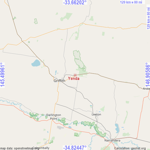
Yenda GPS coordinates[2]
34° 14' 42.9" South, 146° 12' 9.828" East
| Map corner | latitude | longitude |
|---|---|---|
| Upper-left | -33.66202°, | 145.49961° |
| Center: | -34.24525°, | 146.20273° |
| Lower-right: | -34.82447°, | 146.90586° |
| Map W x H: | 129.3×129.3 km | = 80.3×80.3mi |
| max Lat: | -10.58257° ⇑61.5% North |
| Yenda: | -34.24525° |
| min Lat: | ⇓38.5% South -43.31423° |
| min Long | Yenda | max Long |
| 113.53327° | 146.20273° | 153.61246° |
| W 43.6%⇐ | ⇒56.4% E |
Elevation
Elevation of Yenda is 131 m = 430 ft, and this is 9 m = 30 ft above average elevation for this country.
| Max E: |
1715 m = 5627 ft | 25.1% |
| Yenda | 131 m 430 ft | |
| Avg. | 122 m = 400 ft | |
Min E: |
-2 m = -7 ft | 74.9% |
See also: Australia elevation on elevation.city.
Geographical zone
Yenda is located in South temperate zone (between Tropic of Capricorn and the Antarctic Circle). Distance of this Southern Tropic circle is 1201.8 km =746.8 mi to North.| Distance of | km | miles | from Yenda |
|---|---|---|---|
| Equator | 3807.7 | 2366 | to North |
| Tropic Capricorn | 1201.8 | 746.8 | to North |
| Antarctic Circle | 3593.5 | 2232.9 | to South |
| South Pole | 6199.3 | 3852.1 | to South |


Nearby cities:
15 places around Yenda: (largest is in red/bold)
• Ardlethan
65.4 km =40.6 mi,  100°
100°
• Barellan
34.2 km =21.3 mi, 97°
• Bilbul
6.4 km =4 mi,  242°
242°
• Coleambally
68.8 km =42.8 mi,  205°
205°
• Darlington Point
40.6 km =25.2 mi, 207°
• Ganmain
97.9 km =60.8 mi,  128°
128°
• Griffith
14.8 km =9.2 mi,  250°
250°
• Hanwood
17.6 km =10.9 mi, 237°
• Lake Wyangan
16.8 km =10.4 mi,  275°
275°
• Leeton
38.7 km =24 mi,  151°
151°
• Narrandera
64.3 km =40 mi, 150°
• Tharbogang
19.4 km =12.1 mi,  263°
263°
• Ungarie
97.9 km =60.8 mi,  46°
46°
• Yanco
43.6 km =27.1 mi, 154°
• Yoogali
12.4 km =7.7 mi, 240°
Sources, notices
• [Note1] Compared only with cities in Australia existing in our database
• [Src1] Map data: © OpenStreetMap contributors (CC-BY-SA)
• [Src2] Other city data from geonames.org with taken over terms of usage.
• [Src3] Geographical zone / Annual Mean Temperature by Robert A. Rohde @ Wikipedia
