Jerilderie geodata
Jerilderie (New South Wales) is a populated place; located in Australia in Australia/Sydney (GMT+11) time zone. With population of 1,022 people, there are 3790 cities with bigger population in this country. Compared to other cities in Australia, 76.2% of cities are located further ↑North; 58.4% of cities are located further →East and 71.5% of cities have lower elevation than Jerilderie. Note1


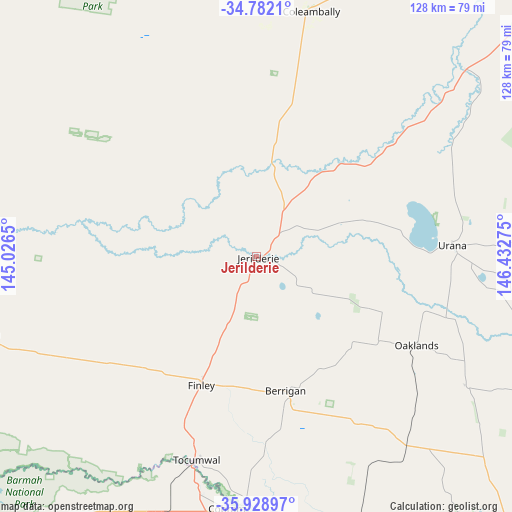
Jerilderie GPS coordinates[2]
35° 21' 27.252" South, 145° 43' 46.632" East
| Map corner | latitude | longitude |
|---|---|---|
| Upper-left | -34.7821°, | 145.0265° |
| Center: | -35.35757°, | 145.72962° |
| Lower-right: | -35.92897°, | 146.43275° |
| Map W x H: | 127.5×127.5 km | = 79.2×79.2mi |
| max Lat: | -10.58257° ⇑76.2% North |
| Jerilderie: | -35.35757° |
| min Lat: | ⇓23.8% South -43.31423° |
| min Long | Jerilderie | max Long |
| 113.53327° | 145.72962° | 153.61246° |
| W 41.6%⇐ | ⇒58.4% E |
Elevation
Elevation of Jerilderie is 110 m = 361 ft, and this is 12 m = 39 ft below average elevation for this country.
| Max E: |
1715 m = 5627 ft | 28.5% |
| Avg. | 122 m = 400 ft | |
| Jerilderie | 110 m = 361 ft | |
Min E: |
-2 m = -7 ft | 71.5% |
See also: Australia elevation on elevation.city.
Geographical zone
Jerilderie is located in South temperate zone (between Tropic of Capricorn and the Antarctic Circle). Distance of this Southern Tropic circle is 1325.5 km =823.6 mi to North.| Distance of | km | miles | from Jerilderie |
|---|---|---|---|
| Equator | 3931.4 | 2442.9 | to North |
| Tropic Capricorn | 1325.5 | 823.6 | to North |
| Antarctic Circle | 3469.8 | 2156 | to South |
| South Pole | 6075.7 | 3775.3 | to South |


Nearby cities:
15 places around Jerilderie: (largest is in red/bold)
• Barooga
61.1 km =38 mi,  182°
182°
• Berrigan
34.3 km =21.3 mi,  167°
167°
• Cobram
63.1 km =39.2 mi,  187°
187°
• Coleambally
63.1 km =39.2 mi,  12°
12°
• Deniliquin
72.9 km =45.3 mi,  254°
254°
• Finley
36 km =22.4 mi,  203°
203°
• Katunga
76.6 km =47.6 mi, 197°
• Lockhart
90.9 km =56.5 mi,  80°
80°
• Mathoura
90.6 km =56.3 mi,  235°
235°
• Mulwala
74.1 km =46 mi,  160°
160°
• Numurkah
85.3 km =53 mi, 197°
• Strathmerton
67.1 km =41.7 mi, 199°
• Tocumwal
52.5 km =32.6 mi, 196°
• Yarrawonga
77.5 km =48.2 mi, 161°
• Yarroweyah
64.9 km =40.3 mi, 193°
Sources, notices
• [Note1] Compared only with cities in Australia existing in our database
• [Src1] Map data: © OpenStreetMap contributors (CC-BY-SA)
• [Src2] Other city data from geonames.org with taken over terms of usage.
• [Src3] Geographical zone / Annual Mean Temperature by Robert A. Rohde @ Wikipedia
