Exeter geodata
Exeter (Tasmania) is a populated place; located in Australia in Australia/Hobart (GMT+11) time zone. With population of 629 people, there are 4491 cities with bigger population in this country. Compared to other cities in Australia, 97.2% of cities are located further ↑North; 53.4% of cities are located further →East and 56.3% of cities have lower elevation than Exeter. Note1


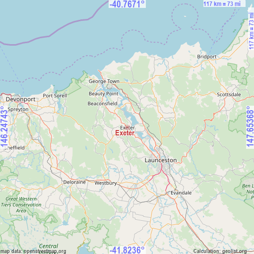
Exeter GPS coordinates[2]
41° 17' 50.964" South, 146° 57' 1.98" East
| Map corner | latitude | longitude |
|---|---|---|
| Upper-left | -40.7671°, | 146.24743° |
| Center: | -41.29749°, | 146.95055° |
| Lower-right: | -41.8236°, | 147.65368° |
| Map W x H: | 117.5×117.5 km | = 73×73mi |
| max Lat: | -10.58257° ⇑97.2% North |
| Exeter: | -41.29749° |
| min Lat: | ⇓2.8% South -43.31423° |
| min Long | Exeter | max Long |
| 113.53327° | 146.95055° | 153.61246° |
| W 46.6%⇐ | ⇒53.4% E |
Elevation
Elevation of Exeter is 56 m = 184 ft, and this is 66 m = 217 ft below average elevation for this country.
| Max E: |
1715 m = 5627 ft | 43.7% |
| Avg. | 122 m = 400 ft | |
| Exeter | 56 m = 184 ft | |
Min E: |
-2 m = -7 ft | 56.3% |
See also: Australia elevation on elevation.city.
Geographical zone
Exeter is located in South temperate zone (between Tropic of Capricorn and the Antarctic Circle). Distance of this Southern Tropic circle is 1985.9 km =1234 mi to North.| Distance of | km | miles | from Exeter |
|---|---|---|---|
| Equator | 4591.9 | 2853.3 | to North |
| Tropic Capricorn | 1985.9 | 1234 | to North |
| Antarctic Circle | 2809.3 | 1745.6 | to South |
| South Pole | 5415.2 | 3364.8 | to South |


Nearby cities:
15 places around Exeter: (largest is in red/bold)
• Beaconsfield
15.4 km =9.6 mi,  313°
313°
• Beauty Point
18.5 km =11.5 mi,  324°
324°
• Blackstone Heights
21.2 km =13.2 mi,  148°
148°
• Dilston
10.2 km =6.3 mi,  110°
110°
• Gravelly Beach
2.4 km =1.5 mi,  58°
58°
• Grindelwald
7.5 km =4.7 mi,  142°
142°
• Hillwood
6.6 km =4.1 mi,  25°
25°
• Invermay
20.5 km =12.7 mi,  131°
131°
• Legana
11 km =6.8 mi, 133°
• Mayfield
18.1 km =11.2 mi,  123°
123°
• Mowbray
20.4 km =12.7 mi, 124°
• Newnham
17.1 km =10.6 mi, 126°
• Riverside
16.1 km =10 mi, 148°
• Rocherlea
19.6 km =12.2 mi, 118°
• Trevallyn
20.6 km =12.8 mi, 141°
Sources, notices
• [Note1] Compared only with cities in Australia existing in our database
• [Src1] Map data: © OpenStreetMap contributors (CC-BY-SA)
• [Src2] Other city data from geonames.org with taken over terms of usage.
• [Src3] Geographical zone / Annual Mean Temperature by Robert A. Rohde @ Wikipedia
