Salyan geodata
Salyan is a seat of a first-order administrative division; located in Azerbaijan in Asia/Baku (GMT+4) time zone. With population of 36,555 people, there are 19 cities with bigger population in this country. Compared to other cities in Azerbaijan, 80.5% of cities are located further ↑North; 72.4% of cities are located further ←West and 92.4% of cities have higher elevation than Salyan. Note1


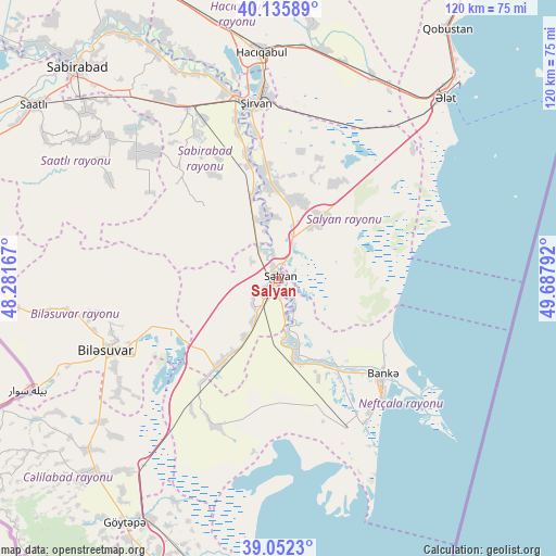
Salyan GPS coordinates[2]
39° 35' 46.356" North, 48° 59' 5.244" East
| Map corner | latitude | longitude |
|---|---|---|
| Upper-left | 40.13589°, | 48.28167° |
| Center: | 39.59621°, | 48.98479° |
| Lower-right: | 39.0523°, | 49.68792° |
| Map W x H: | 120.5×120.5 km | = 74.9×74.9mi |
| max Lat: | 41.75259° ⇑80.5% North |
| Salyan: | 39.59621° |
| min Lat: | ⇓19.5% South 38.45598° |
| min Long | Salyan | max Long |
| 44.84846° | 48.98479° | 50.84003° |
| W 72.4%⇐ | ⇒27.6% E |
Elevation
Elevation of Salyan is -17 m = -56 ft, and this is 400 m = 1312 ft below average elevation for this country.
| Max E: |
2211 m = 7254 ft | 92.4% |
| Avg. | 383 m = 1257 ft | |
| Salyan | -17 m = -56 ft | |
Min E: |
-26 m = -85 ft | 7.6% |
See also: Azerbaijan elevation on elevation.city.
Geographical zone
Salyan is located in North temperate zone (between Tropic of Cancer and the Arctic Circle). Distance of this Northern Tropic circle is 1796.8 km =1116.5 mi to South.| Distance of | km | miles | from Salyan |
|---|---|---|---|
| North Pole | 5604.4 | 3482.4 | to North |
| Arctic Circle | 2998.5 | 1863.2 | to North |
| Tropic Cancer | 1796.8 | 1116.5 | to South |
| Equator | 4402.7 | 2735.7 | to South |


Nearby cities:
15 places around Salyan: (largest is in red/bold)
• Hacıqabul
49.3 km =30.6 mi,  355°
355°
• Jalilabad
60.3 km =37.5 mi,  224°
224°
• Mughan
57.7 km =35.9 mi,  345°
345°
• Neftçala
33.2 km =20.6 mi,  137°
137°
• Prishibinskoye
62.7 km =39 mi,  212°
212°
• Pushkino
40.7 km =25.3 mi,  247°
247°
• Qaraçala
24.8 km =15.4 mi, 350°
• Qobustan
65.2 km =40.5 mi,  34°
34°
• Saatlı
64.5 km =40.1 mi,  305°
305°
• Sabirabad
63.1 km =39.2 mi,  316°
316°
• Severo-Vostotchnyi Bank
30.5 km =19 mi,  132°
132°
• Sovetabad
34.9 km =21.7 mi,  145°
145°
• Xıllı
21 km =13 mi, 151°
• Şirvan
38.3 km =23.8 mi, 352°
• Əhmədbəyli
59.8 km =37.2 mi,  301°
301°
Sources, notices
• [Note1] Compared only with cities in Azerbaijan existing in our database
• [Src1] Map data: © OpenStreetMap contributors (CC-BY-SA)
• [Src2] Other city data from geonames.org with taken over terms of usage.
• [Src3] Geographical zone / Annual Mean Temperature by Robert A. Rohde @ Wikipedia
