Hacıqabul geodata
Hacıqabul is a seat of a first-order administrative division; located in Azerbaijan in Asia/Baku (GMT+4) time zone. With population of 23,102 people, there are 35 cities with bigger population in this country. Compared to other cities in Azerbaijan, 67% of cities are located further ↑North; 71.9% of cities are located further ←West and 83.8% of cities have higher elevation than Hacıqabul. Note1


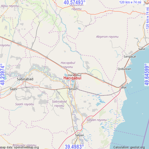
Hacıqabul GPS coordinates[2]
40° 2' 19.464" North, 48° 56' 34.296" East
| Map corner | latitude | longitude |
|---|---|---|
| Upper-left | 40.57493°, | 48.23974° |
| Center: | 40.03874°, | 48.94286° |
| Lower-right: | 39.4983°, | 49.64599° |
| Map W x H: | 119.7×119.7 km | = 74.4×74.4mi |
| max Lat: | 41.75259° ⇑67% North |
| Hacıqabul: | 40.03874° |
| min Lat: | ⇓33% South 38.45598° |
| min Long | Hacıqabul | max Long |
| 44.84846° | 48.94286° | 50.84003° |
| W 71.9%⇐ | ⇒28.1% E |
Elevation
Elevation of Hacıqabul is 0 m = 0 ft, and this is 383 m = 1257 ft below average elevation for this country.
| Max E: |
2211 m = 7254 ft | 83.8% |
| Avg. | 383 m = 1257 ft | |
| Hacıqabul | 0 m = 0 ft | |
Min E: |
-26 m = -85 ft | 16.2% |
See also: Azerbaijan elevation on elevation.city.
Geographical zone
Hacıqabul is located in North temperate zone (between Tropic of Cancer and the Arctic Circle). Distance of this Northern Tropic circle is 1846 km =1147.1 mi to South.| Distance of | km | miles | from Hacıqabul |
|---|---|---|---|
| North Pole | 5555.2 | 3451.8 | to North |
| Arctic Circle | 2949.3 | 1832.6 | to North |
| Tropic Cancer | 1846 | 1147.1 | to South |
| Equator | 4451.9 | 2766.3 | to South |


Nearby cities:
15 places around Hacıqabul: (largest is in red/bold)
• Korgöz
64.9 km =40.3 mi,  62°
62°
• Mughan
12.5 km =7.8 mi,  302°
302°
• Puta
67.4 km =41.9 mi, 64°
• Qaraçala
24.8 km =15.4 mi,  180°
180°
• Qobustan
40.2 km =25 mi,  83°
83°
• Qobustan
55 km =34.2 mi,  358°
358°
• Saatlı
50.3 km =31.3 mi,  256°
256°
• Sabirabad
39.8 km =24.7 mi,  265°
265°
• Salyan
49.3 km =30.6 mi, 175°
• Sanqaçal
46.7 km =29 mi,  71°
71°
• Shamakhi
70.7 km =43.9 mi,  338°
338°
• Xıllı
69 km =42.9 mi,  168°
168°
• Şirvan
11.3 km =7 mi,  186°
186°
• Şonqar
64 km =39.8 mi, 60°
• Əhmədbəyli
50.2 km =31.2 mi,  249°
249°
Sources, notices
• [Note1] Compared only with cities in Azerbaijan existing in our database
• [Src1] Map data: © OpenStreetMap contributors (CC-BY-SA)
• [Src2] Other city data from geonames.org with taken over terms of usage.
• [Src3] Geographical zone / Annual Mean Temperature by Robert A. Rohde @ Wikipedia
