Şirvan geodata
Şirvan (Shirvan) is a seat of a first-order administrative division; located in Azerbaijan in Asia/Baku (GMT+4) time zone. With population of 70,220 people, there are 8 cities with bigger population in this country. Compared to other cities in Azerbaijan, 70.3% of cities are located further ↑North; 70.3% of cities are located further ←West and 90.3% of cities have higher elevation than Şirvan. Note1


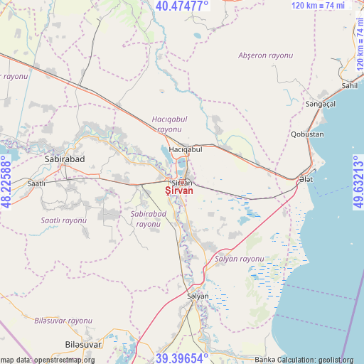
Şirvan GPS coordinates[2]
39° 56' 16.008" North, 48° 55' 44.4" East
| Map corner | latitude | longitude |
|---|---|---|
| Upper-left | 40.47477°, | 48.22588° |
| Center: | 39.93778°, | 48.929° |
| Lower-right: | 39.39654°, | 49.63213° |
| Map W x H: | 119.9×119.9 km | = 74.5×74.5mi |
| max Lat: | 41.75259° ⇑70.3% North |
| Şirvan: | 39.93778° |
| min Lat: | ⇓29.7% South 38.45598° |
| min Long | Şirvan | max Long |
| 44.84846° | 48.929° | 50.84003° |
| W 70.3%⇐ | ⇒29.7% E |
Elevation
Elevation of Şirvan is -15 m = -49 ft, and this is 398 m = 1306 ft below average elevation for this country.
| Max E: |
2211 m = 7254 ft | 90.3% |
| Avg. | 383 m = 1257 ft | |
| Şirvan | -15 m = -49 ft | |
Min E: |
-26 m = -85 ft | 9.7% |
See also: Şirvan elevation on elevation.city.
Geographical zone
Şirvan is located in North temperate zone (between Tropic of Cancer and the Arctic Circle). Distance of this Northern Tropic circle is 1834.7 km =1140 mi to South.| Distance of | km | miles | from Şirvan |
|---|---|---|---|
| North Pole | 5566.4 | 3458.8 | to North |
| Arctic Circle | 2960.5 | 1839.6 | to North |
| Tropic Cancer | 1834.7 | 1140 | to South |
| Equator | 4440.7 | 2759.3 | to South |


Nearby cities:
15 places around Şirvan: (largest is in red/bold)
• Hacıqabul
11.3 km =7 mi,  6°
6°
• Mughan
20.2 km =12.6 mi,  332°
332°
• Neftçala
68.1 km =42.3 mi,  156°
156°
• Pushkino
62.6 km =38.9 mi,  211°
211°
• Qaraçala
13.5 km =8.4 mi,  176°
176°
• Qobustan
44.2 km =27.5 mi,  68°
68°
• Qobustan
66.2 km =41.1 mi,  359°
359°
• Saatlı
47.8 km =29.7 mi,  269°
269°
• Sabirabad
39.3 km =24.4 mi,  281°
281°
• Salyan
38.3 km =23.8 mi,  172°
172°
• Sanqaçal
52.3 km =32.5 mi,  60°
60°
• Severo-Vostotchnyi Bank
64.6 km =40.1 mi, 155°
• Xıllı
58.3 km =36.2 mi, 165°
• Şonqar
71.2 km =44.2 mi,  53°
53°
• Əhmədbəyli
46.3 km =28.8 mi,  262°
262°
Sources, notices
• [Note1] Compared only with cities in Azerbaijan existing in our database
• [Src1] Map data: © OpenStreetMap contributors (CC-BY-SA)
• [Src2] Other city data from geonames.org with taken over terms of usage.
• [Src3] Geographical zone / Annual Mean Temperature by Robert A. Rohde @ Wikipedia
