Mughan geodata
Mughan (Hacıqabul) is a populated place; located in Azerbaijan in Asia/Baku (GMT+4) time zone. With population of 4,410 people, there are 112 cities with bigger population in this country. Compared to other cities in Azerbaijan, 64.9% of cities are located further ↑North; 68.1% of cities are located further ←West and 90.3% of cities have higher elevation than Mughan. Note1


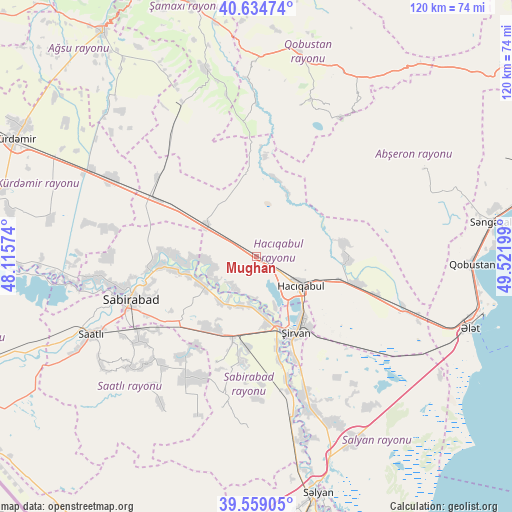
Mughan GPS coordinates[2]
40° 5' 56.472" North, 48° 49' 7.896" East
| Map corner | latitude | longitude |
|---|---|---|
| Upper-left | 40.63474°, | 48.11574° |
| Center: | 40.09902°, | 48.81886° |
| Lower-right: | 39.55905°, | 49.52199° |
| Map W x H: | 119.6×119.6 km | = 74.3×74.3mi |
| max Lat: | 41.75259° ⇑64.9% North |
| Mughan: | 40.09902° |
| min Lat: | ⇓35.1% South 38.45598° |
| min Long | Mughan | max Long |
| 44.84846° | 48.81886° | 50.84003° |
| W 68.1%⇐ | ⇒31.9% E |
Elevation
Elevation of Mughan is -15 m = -49 ft, and this is 398 m = 1306 ft below average elevation for this country.
| Max E: |
2211 m = 7254 ft | 90.3% |
| Avg. | 383 m = 1257 ft | |
| Mughan | -15 m = -49 ft | |
Min E: |
-26 m = -85 ft | 9.7% |
See also: Azerbaijan elevation on elevation.city.
Geographical zone
Mughan is located in North temperate zone (between Tropic of Cancer and the Arctic Circle). Distance of this Northern Tropic circle is 1852.7 km =1151.2 mi to South.| Distance of | km | miles | from Mughan |
|---|---|---|---|
| North Pole | 5548.5 | 3447.7 | to North |
| Arctic Circle | 2942.6 | 1828.4 | to North |
| Tropic Cancer | 1852.7 | 1151.2 | to South |
| Equator | 4458.6 | 2770.4 | to South |


Nearby cities:
15 places around Mughan: (largest is in red/bold)
• Aghsu
63.3 km =39.3 mi,  325°
325°
• Hacıqabul
12.5 km =7.8 mi,  122°
122°
• Imishli
69.5 km =43.2 mi,  248°
248°
• Kyurdarmir
62.4 km =38.8 mi,  295°
295°
• Qaraçala
33 km =20.5 mi,  162°
162°
• Qobustan
49.2 km =30.6 mi,  10°
10°
• Qobustan
50.5 km =31.4 mi,  92°
92°
• Saatlı
42.6 km =26.5 mi,  244°
244°
• Sabirabad
30.8 km =19.1 mi, 250°
• Salyan
57.7 km =35.9 mi,  165°
165°
• Sanqaçal
55.4 km =34.4 mi,  81°
81°
• Shamakhi
61.1 km =38 mi,  345°
345°
• Şirvan
20.2 km =12.6 mi,  152°
152°
• Şonqar
70.7 km =43.9 mi,  69°
69°
• Əhmədbəyli
43.7 km =27.2 mi, 236°
Sources, notices
• [Note1] Compared only with cities in Azerbaijan existing in our database
• [Src1] Map data: © OpenStreetMap contributors (CC-BY-SA)
• [Src2] Other city data from geonames.org with taken over terms of usage.
• [Src3] Geographical zone / Annual Mean Temperature by Robert A. Rohde @ Wikipedia
