Neftçala geodata
Neftçala is a seat of a first-order administrative division; located in Azerbaijan in Asia/Baku (GMT+4) time zone. With population of 18,661 people, there are 43 cities with bigger population in this country. Compared to other cities in Azerbaijan, 87% of cities are located further ↑North; 76.2% of cities are located further ←West and 97.8% of cities have higher elevation than Neftçala. Note1


Neftçala GPS coordinates[2]
39° 22' 36.48" North, 49° 14' 49.2" East
| Map corner | latitude | longitude |
|---|---|---|
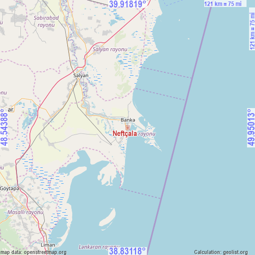
| Upper-left | 39.91819°, | 48.54388° |
| Center: | 39.3768°, | 49.247° |
| Lower-right: | 38.83118°, | 49.95013° |
| Map W x H: | 120.9×120.9 km | = 75.1×75.1mi |
| max Lat: | 41.75259° ⇑87% North |
| Neftçala: | 39.3768° |
| min Lat: | ⇓13% South 38.45598° |
| min Long | Neftçala | max Long |
| 44.84846° | 49.247° | 50.84003° |
| W 76.2%⇐ | ⇒23.8% E |
Elevation
Elevation of Neftçala is -24 m = -79 ft, and this is 407 m = 1335 ft below average elevation for this country.
| Max E: |
2211 m = 7254 ft | 97.8% |
| Avg. | 383 m = 1257 ft | |
| Neftçala | -24 m = -79 ft | |
Min E: |
-26 m = -85 ft | 2.2% |
See also: Azerbaijan elevation on elevation.city.
Geographical zone
Neftçala is located in North temperate zone (between Tropic of Cancer and the Arctic Circle). Distance of this Northern Tropic circle is 1772.4 km =1101.3 mi to South.| Distance of | km | miles | from Neftçala |
|---|---|---|---|
| North Pole | 5628.8 | 3497.6 | to North |
| Arctic Circle | 3022.9 | 1878.3 | to North |
| Tropic Cancer | 1772.4 | 1101.3 | to South |
| Equator | 4378.3 | 2720.5 | to South |


Nearby cities:
15 places around Neftçala: (largest is in red/bold)
• Boradigah
67.9 km =42.2 mi,  223°
223°
• Hacıqabul
78.1 km =48.5 mi,  340°
340°
• Haftoni
80 km =49.7 mi,  211°
211°
• Jalilabad
67.6 km =42 mi,  254°
254°
• Lankaran
77.2 km =48 mi, 206°
• Masally
62.9 km =39.1 mi,  232°
232°
• Prishibinskoye
63.1 km =39.2 mi,  243°
243°
• Pushkino
61 km =37.9 mi,  278°
278°
• Qaraçala
55.6 km =34.5 mi,  331°
331°
• Qobustan
79.7 km =49.5 mi,  10°
10°
• Salyan
33.2 km =20.6 mi,  317°
317°
• Severo-Vostotchnyi Bank
3.8 km =2.4 mi,  1°
1°
• Sovetabad
5.3 km =3.3 mi, 212°
• Xıllı
13.8 km =8.6 mi,  295°
295°
• Şirvan
68.1 km =42.3 mi, 336°
Sources, notices
• [Note1] Compared only with cities in Azerbaijan existing in our database
• [Src1] Map data: © OpenStreetMap contributors (CC-BY-SA)
• [Src2] Other city data from geonames.org with taken over terms of usage.
• [Src3] Geographical zone / Annual Mean Temperature by Robert A. Rohde @ Wikipedia
