Xıllı geodata
Xıllı (Neftçala) is a populated place; located in Azerbaijan in Asia/Baku (GMT+4) time zone. With population of 3,896 people, there are 119 cities with bigger population in this country. Compared to other cities in Azerbaijan, 84.3% of cities are located further ↑North; 74.6% of cities are located further ←West and 100% of cities have higher elevation than Xıllı. Note1


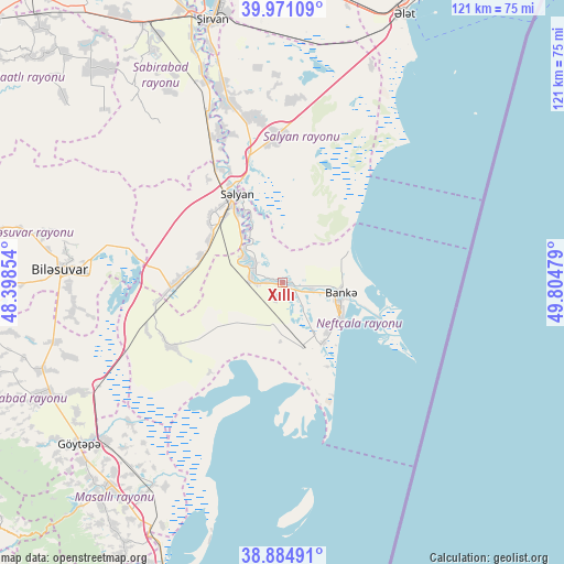
Xıllı GPS coordinates[2]
39° 25' 48.432" North, 49° 6' 5.976" East
| Map corner | latitude | longitude |
|---|---|---|
| Upper-left | 39.97109°, | 48.39854° |
| Center: | 39.43012°, | 49.10166° |
| Lower-right: | 38.88491°, | 49.80479° |
| Map W x H: | 120.8×120.8 km | = 75.1×75.1mi |
| max Lat: | 41.75259° ⇑84.3% North |
| Xıllı: | 39.43012° |
| min Lat: | ⇓15.7% South 38.45598° |
| min Long | Xıllı | max Long |
| 44.84846° | 49.10166° | 50.84003° |
| W 74.6%⇐ | ⇒25.4% E |
Elevation
Elevation of Xıllı is -26 m = -85 ft, and this is 409 m = 1342 ft below average elevation for this country.
| Max E: |
2211 m = 7254 ft | 100% |
| Avg. | 383 m = 1257 ft | |
| Xıllı | -26 m = -85 ft | |
Min E: |
-26 m = -85 ft | 0% |
See also: Azerbaijan elevation on elevation.city.
Geographical zone
Xıllı is located in North temperate zone (between Tropic of Cancer and the Arctic Circle). Distance of this Northern Tropic circle is 1778.3 km =1105 mi to South.| Distance of | km | miles | from Xıllı |
|---|---|---|---|
| North Pole | 5622.8 | 3493.8 | to North |
| Arctic Circle | 3017 | 1874.7 | to North |
| Tropic Cancer | 1778.3 | 1105 | to South |
| Equator | 4384.2 | 2724.2 | to South |


Nearby cities:
15 places around Xıllı: (largest is in red/bold)
• Boradigah
65.1 km =40.5 mi,  211°
211°
• Hacıqabul
69 km =42.9 mi,  348°
348°
• Jalilabad
57.9 km =36 mi,  244°
244°
• Lankaran
78.2 km =48.6 mi,  196°
196°
• Masally
57.8 km =35.9 mi,  220°
220°
• Mughan
78.2 km =48.6 mi,  341°
341°
• Neftçala
13.8 km =8.6 mi,  115°
115°
• Prishibinskoye
55.7 km =34.6 mi,  231°
231°
• Pushkino
47.9 km =29.8 mi,  273°
273°
• Qaraçala
45.2 km =28.1 mi, 341°
• Qobustan
77.2 km =48 mi,  20°
20°
• Salyan
21 km =13 mi,  331°
331°
• Severo-Vostotchnyi Bank
12.7 km =7.9 mi,  99°
99°
• Sovetabad
14.2 km =8.8 mi,  137°
137°
• Şirvan
58.3 km =36.2 mi, 345°
Sources, notices
• [Note1] Compared only with cities in Azerbaijan existing in our database
• [Src1] Map data: © OpenStreetMap contributors (CC-BY-SA)
• [Src2] Other city data from geonames.org with taken over terms of usage.
• [Src3] Geographical zone / Annual Mean Temperature by Robert A. Rohde @ Wikipedia
